
Whangaokeno / East Island facts for kids
|
Whangaokeno (Māori)
|
|
|---|---|

View of East Island from East Cape
|
|
| Geography | |
| Location | Gisborne Region |
| Coordinates | 37°41′28.65″S 178°34′33.10″E / 37.6912917°S 178.5758611°E |
| Area | 13 ha (32 acres) |
| Highest elevation | 129 m (423 ft) |
| Administration | |
| Demographics | |
| Population | 0 |
Whangaokeno / East Island is a small island located about 2 kilometers (1.2 miles) east of East Cape in the North Island of New Zealand. This island is quite small, covering an area of about 13 hectares (32 acres). It rises to a height of 129 meters (423 feet) above the sea.
Contents
About Whangaokeno / East Island
Whangaokeno / East Island is known for its interesting history, especially concerning a famous lighthouse. The island is part of the Gisborne District in New Zealand. Even though it's small, it plays a role in the local history and landscape.
The East Cape Lighthouse Story
The East Cape Lighthouse was first built on Whangaokeno / East Island in the year 1900. Imagine building a lighthouse on a small island! It was a big project.
However, the island has a few challenges. It often experiences earthquakes, which can shake the ground. Also, its steep cliffs can lead to landslides, where rocks and soil slide down.
By 1920, people realized that the lighthouse was in danger because of these earthquakes and landslides. It was decided that it would be safer to move the lighthouse to the mainland. So, in 1922, the light was turned off on the island. The lighthouse was then carefully moved to its current, safer spot on the mainland.
Island's Official Name
For a long time, the island was known as East Island. But on June 10, 2019, its official name was changed. It is now known as Whangaokeno / East Island. This new name includes its traditional Māori name, Whangaokeno.
Historical Connections
The area around Whangaokeno / East Island has historical importance for Māori people. The Takitimu waka (a traditional Māori canoe) is said to have landed at Whangaōkena, which is another name for East Cape. This shows the long history and connection of Māori people to this part of New Zealand.
Images for kids
-
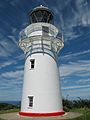
East Island was the original location of the East Cape Lighthouse.
-
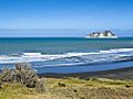
East Island seen from the bottom of the Otiki Hill


