Whissendine Brook facts for kids
Quick facts for kids Whissendine Brook |
|
|---|---|

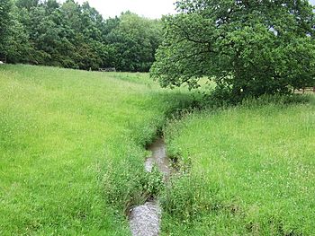
The brook upstream of Whissendine
|
|
|
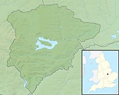
Location of the river mouth in Rutland
|
|
| Country | England |
| Counties | Rutland, Leicestershire |
| Physical characteristics | |
| Main source | Cold Overton, Leicestershire 182 m (597 ft) 52°40′57″N 0°48′24″W / 52.682448°N 0.806718°W |
| River mouth | Langham Brook Whissendine, Rutland 94 m (308 ft) 52°44′29″N 0°45′57″W / 52.741364°N 0.765782°W |
| Length | 10.5 km (6.5 mi) |
| Basin features | |
| Basin size | 14.4 km2 (5.6 sq mi) |
The Whissendine Brook is a small stream located in the East Midlands part of England. It flows into the Langham Brook and is a small but important part of the larger River Soar river system.
Contents
Where Does the Brook Flow?
The Whissendine Brook starts its journey west of Cold Overton in Leicestershire. It flows towards the northeast, passing by the village. Then, it crosses the county line into Rutland.
Journey Through Whissendine Village
As the brook continues, it flows through a gentle valley. It actually divides the village of Whissendine into two parts. The older part of the village is on higher ground to the east. Newer homes are found around a restored 19th-century windmill to the west.
In the middle of the village, a smaller stream joins the Whissendine Brook from the south. This spot was once called Horse Pit Lane. People used the brook here to wash horses and carts.
Joining the Langham Brook
After leaving Whissendine village, the brook keeps flowing north. It passes through farm fields. Soon, it meets the Langham Brook right on the border of Leicestershire.
Keeping the Brook Clean
In 2016, experts checked the Whissendine Brook's health. They found its overall condition was 'Poor'. This was due to several issues. These included pollution from waste, animals making the water dirty, and too many nutrients from farm fields. These problems can harm the plants and animals living in the water. Efforts are made to improve the water quality.
 | Valerie Thomas |
 | Frederick McKinley Jones |
 | George Edward Alcorn Jr. |
 | Thomas Mensah |


