
River Soar facts for kids
Quick facts for kids River Soar |
|
|---|---|

Bridge over the Soar next to the Navigation, Barrow upon Soar
|
|
| Country | United Kingdom |
| Country within the UK | England |
| Counties | Leicestershire, Warwickshire |
| Cities | Leicester |
| Towns | Loughborough |
| Physical characteristics | |
| Main source | Monks Kirby, Warwickshire 132 m (433 ft) 52°28′15″N 1°18′22″W / 52.470807°N 1.305981°W |
| River mouth | Trent Lock, Leicestershire 30 m (98 ft) 52°52′23″N 1°16′06″W / 52.8731°N 1.2682°W |
| Length | 95 km (59 mi) |
| Discharge (location 2) |
|
| Basin features | |
| Basin size | 1,386 km2 (535 sq mi) |
| Tributaries |
|
| Progression : Soar — Trent — Humber | |

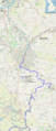
The River Soar is a main river in the East Midlands of England. It flows through Leicestershire and is a major branch of the River Trent. The Soar starts between Hinckley and Lutterworth. It then flows north through Leicester, where it meets the Grand Union Canal. The river continues through the Soar Valley, passing Loughborough and Kegworth. Finally, it joins the Trent at the county border. In the 1700s, parts of the Soar were made easy for boats to travel on. Later, in the 1800s, it connected to a bigger canal system.
Contents
What's in a Name?
The name Soar comes from very old river names. These names often come from a root word meaning "to flow." Many rivers in Europe have similar names, like the Saar in Germany or the Loire in France.
Some people believe the River Soar was once called the Leir. This idea comes from the names of places like Leicester, Loughborough, and Leire. These names might have come from the old name of the river itself.
The River's Journey

The River Soar begins near Wibtoft in Warwickshire. It flows north and meets the Soar Brook near Sharnford. The river then moves northeast, passing Croft, Narborough, and Littlethorpe.
Near Leicester, the Sence joins the Soar near Enderby. Before going through the city center, it meets the Grand Union Canal at Aylestone. Here, the River Biam also joins.
After passing Freemens Weir, the river splits and rejoins the canal. This creates an area in Leicester called Bede Island. One part of the river, called 'The Mile Straight', has straight banks like a canal. Further on, the river splits again, forming Frog Island and Abbey Park. It comes back together at Belgrave, flowing past the National Space Centre.
Outside the city, the Soar passes Birstall. It then winds through the lakes of Watermead Country Park until it reaches Wanlip. The river meets the River Wreake near Cossington Mill. Another river, the Rothley Brook, joins a bit further downstream.
The Soar continues northeast to Mountsorrel. It then flows between Quorn and Barrow-on-Soar. Here, a part of the canal goes into Loughborough, but the river itself passes east of the town at Cotes.
Downstream of Stanford on Soar, the river becomes the border between Nottinghamshire and Leicestershire. Between Stanford and Normanton on Soar, the canal rejoins the river. The river then continues to Zouch, passing a bend called the ‘Devils Elbow’ to reach Kegworth. Downstream of Kegworth, it meets the Kingston Brook. Finally, it flows into the Trent at Trent Lock.
River Health and Pollution

The River Soar is home to lots of wildlife, including birds, fish, and plants. It's a popular spot for nature lovers. The river used to be famous for its unusual pink color. This was because of waste from Leicester's busy textile factories.
However, with the textile industry moving away and clean-up efforts by the Environment Agency, the river looks natural again. Now, any company wanting to put waste into the river must get permission from the Environment Agency. The amount and type of waste are carefully controlled.
The Environment Agency constantly checks the river's pollution levels. The water quality in Leicester is generally good. But, it gets worse just downstream of the city, where the Wanlip sewage treatment works releases water into the river.
Unfortunately, more tourism has also caused some environmental issues. Boats can damage plants with their hulls and propellers. They can also stir up the water, making it cloudy. This stops sunlight from reaching underwater plants, which need light to grow. Sewage works also negatively affect river life.
A Look Back: The River's History

The River Soar has a long history of changes and developments.
- 1634: Thomas Skipwith tried to make the Soar wide enough for barges and boats. This plan was never finished.
- 1794: The Leicester Canal opened, making the Soar navigable for about 40 miles (64 km). A branch line, the Charnwood Forest Canal, also opened. This branch mostly used rail tracks instead of water.
- 1795: Another branch opened from the Leicester Canal to Melton Mowbray. This line used the River Wreake and was very successful. Plans were made to extend it further to Oakham in Rutland.
- 1797: A big plan to extend the Leicester Canal much further south was announced. The idea was to link the Soar with the River Nene. However, they ran out of money. The canal only reached part of the way, ending far from any major town.
- 1802: The Oakham Canal opened after costing a lot of money. It was 15 miles (24 km) long with 19 locks. This allowed boats to travel from Rutland onto the River Soar.
- 1809: The Leicestershire & Northamptonshire Canal was extended to Market Harborough. It was now a big waterway, connecting south Leicestershire to the River Trent. But it still didn't connect to the Grand Junction Canal.
- 1814: A new link opened between the Leicester waterways and the Grand Junction Canal. It was called the Grand Union Canal.
- 1832: The Leicester and Swannington Railway opened. It brought coal from Leicestershire to a wharf by the canal. This made it cheaper to send coal south to London.
- 1848: The owners of the River Soar Navigation finally closed the Charnwood Forest Canal branch, which hadn't been used much since 1801.
- 1877: The Melton Mowbray Navigation also closed, leaving Melton Mowbray without a waterway connection.
- 1931: The entire waterway from Norton Junction to Leicester and Long Eaton joined with the Grand Junction Canal. This created the larger Grand Union Canal we know today.
River Soar and Industry

Before the late 1700s, the River Soar was too small for barges. But the Leicester Canal made it navigable for about 40 miles (64 km). This expansion helped industries grow along the canal. Transport by canal was very important for businesses. This included mills, brewing factories, and bridges.
By 1895, there were many hosiery (sock and stocking) factories in the area. In Leicester, this industry employed a large part of the population. Hosiery factories needed a steady supply of water and good transport links. So, they were built right next to the canal. The excellent transport provided by the Grand Union Canal helped the hosiery industry grow quickly.
Many factories eventually moved to bigger sites. This left space for other businesses like shoe making, printing, or box making. In the 1800s, railways started to compete with canals. This reduced canal profits. Many canal companies either turned their canals into railways or were bought by railway companies.
By the 1960s, many factories and warehouses along the river were empty and falling apart. Leicester City Council started a plan to rebuild the waterfront. They are building new apartments by the water. This makes the area look much nicer. People like living by the water, but they don't like seeing old, run-down buildings.
The redevelopment plan included building the Walkers stadium, home to Leicester City F.C., in 2002. This stadium transformed a waste-ground into a modern building. Old warehouses have also been turned into student housing for De Montfort University. This has made the area more valuable.
On the east bank of the Soar in central Leicester is Donisthorpe and Company, a textile producer. Their factory, Friars' Mill, is one of the oldest mills in the East Midlands. Manufacturing has happened on this site since the 1730s. The mill was given special protected status in 1975. Other nearby buildings, like a Victorian pump house, were also protected.
Donisthorpe Company left the factory in 1983. This caused worries about the mill's future. The building was empty for many years and fell into disrepair. In 2012, a fire destroyed its roof and most of the inside. Later that year, Leicester City Council decided to buy and restore the building.
River Legends
Geoffrey of Monmouth, an old writer, said that Leicester was named after a king called Leir. He claimed that King Leir was buried in an underground room beneath the river near Leicester. This place was supposedly for the god Janus. The names Leir and Leicester likely come from the old name of the River Soar itself.
There was also a legend that the body of King Richard III was thrown into the river. This was supposedly during the time of Henry VIII. Because of this story, the bridge carrying the A47 across the Soar in Leicester is called "King Richard's Bridge." However, in 2013, it was confirmed that a skeleton found under a car park was indeed Richard III's. His remains were later reburied in Leicester Cathedral.
Fun on the Soar: Tourism

Today, the River Soar is more about tourism than industry. Holiday narrowboat cruises are very popular. It's a relaxing way to see the countryside and enjoy nature. The paths next to the canal are great for cycling, rambling, horse-riding, and picnicking.
The river is also a popular spot for fishing. You can find large carp, chub, bream, roach, and perch in the canal. Some parts of the river also have dace and barbel.
River Soar and Sport
The part of the River Soar that goes through central Leicester is known as the 'Mile Straight'. This stretch is home to several rowing clubs. These include De Montfort University Rowing Club, the University of Leicester Boat Club, and Leicester Rowing Club. Leicester Rowing Club is a rowing and sculling club that started in 1882.
Images for kids
-
Map of the navigable part of the River Soar (in dark green) and it's connection to the Leicester Line of the Grand Union Canal (dark blue)

