
Aylestone facts for kids
Quick facts for kids Aylestone |
|
|---|---|
 Bridge over the canal at Aylestone Meadows |
|

Aylestone
|
|
| Population | 11,151 (2011) |
| OS grid reference | SK573009 |
| • London | 101 mi (163 km) S |
| Unitary authority | |
| Ceremonial county | |
| Region | |
| Country | England |
| Sovereign state | United Kingdom |
| Post town | Leicester |
| Postcode district | LE2 |
| Dialling code | 0116 |
| Police | Leicestershire |
| Fire | Leicestershire |
| Ambulance | East Midlands |
| EU Parliament | East Midlands |
| UK Parliament |
|
Aylestone is a part of Leicester, a city in England. It's located southwest of the city centre, near the River Soar. Long ago, Aylestone was a separate village. But as Leicester grew bigger, Aylestone became part of the city.
The main church, St Andrew's, was built mostly in the 1200s. The area around this church still feels like an old village. Locals often call it 'the village' or 'old Aylestone'. This old part is now surrounded by houses built in the late 1800s (called Aylestone Park) and in the 1900s.
Contents
Aylestone's Past: A Journey Through Time
The name 'Aylestone' likely comes from an old Anglo-Saxon name, meaning 'Aegel's settlement'. Aylestone was first written about in the Domesday Book in 1086. This was a famous survey of England ordered by William the Conqueror.
Aylestone was once owned by powerful families, including the Earls of Leicester. Later, it passed to the Harcourt and Pembrugge families. Eventually, it came into the hands of the Vernon family. In 1565, it became part of the Manners family's lands. They later became the Dukes of Rutland.
In 1869, the Duke of Rutland sold the estate. In 1891, Aylestone officially became part of Leicester. At that time, the village covered a large area of about 1,723 acres.
Around 1766, the open fields of Aylestone were divided into smaller, private fields. At this time, coal from nearby areas was brought into Leicester through Aylestone. Packhorses carried the coal across the Aylestone Packhorse Bridge over the River Soar flood plain. This area is now known as 'Aylestone Meadows'.
Aylestone Hall: A Historic Building
During the English Civil War in 1645, King Charles I and Prince Rupert used Aylestone Hall as their base. This was when they attacked Leicester.
Over the years, Aylestone Hall has been used for many things. In 1846, it was a school for girls. Later, it was a private home. During World War II, the army used it. In 1950, Leicester City Council bought the hall. After some work, it opened in 1954 as a public park with a restaurant and a bowling club.
Aylestone Hall was updated again in 2003. It was turned into three homes and a clubhouse. During this work, builders found very old wooden parts from the 1300s! This showed that parts of the hall were much older than people thought. The hall also has stone parts from the 1500s. Many of the old-looking features, like the star-shaped chimneys, were added in 1850.

There is a packhorse bridge from the 1400s at the west end of Marsden Lane. It crosses the River Soar with eleven arches.
Aylestone's Green Spaces
Aylestone Park is an area of houses that grew between Leicester and the old Aylestone village. Most of these houses were built after 1875.
Aylestone Meadows is a big area of playing fields and water-meadows nearby. It helps keep the area feeling a bit like the countryside. In 2003, it was made a Local Nature Reserve, which means it's a special place for nature.
In 2011, there were plans to build a sports pitch and car park in Aylestone Meadows. But many groups and local people worked together to stop it. They used an online petition, and the plans were rejected.
People and Community in Aylestone
In 2001, about 10,801 people lived in the Aylestone area. The village itself grew a lot in the late 1800s. In 1871, there were 450 people. By 1891, there were 5,381!
Community Life and Pastimes
The Aylestone Boathouse was a large wooden building built around 1911. It was near a canal and allowed boats to move between the canal and the River Soar. Later, a brick ballroom, a restaurant, and tennis courts were added. During World War II, it was used as an engineering factory. The boathouse was taken down around 1980. The ballroom later became a bingo hall, but it was also taken down and replaced by houses.
Getting Around Aylestone: Transport Links
The canalised River Soar flows north from Aylestone. South of Aylestone, the river was too shallow for boats. So, a canal was dug from just north of the packhorse bridge to Market Harborough. This canal connected to the Grand Junction Canal. The section from Loughborough to Aylestone opened in 1794.
A horse tram service started in Aylestone in 1878. The tram lines were extended in 1884. In 1904, the trams became electric. The tram services stopped in 1947.
The Great Central Railway passed close to Aylestone village. It was built on a high bank. Even though the train line opened in 1899, there was no station in Aylestone. The closest stations were in Leicester and Whetstone.
Today, you can catch Arriva Midlands buses (services 84, 85, and 87) that run often into Leicester along Aylestone Road. Centrebus also has routes (83/83A) that go to the Gilmorton Avenue estate.
Learning in Aylestone: Schools and Education
In 1786, people in Aylestone asked the Duke of Rutland to start a Charity School for 30 children. In 1844, a National School opened on land given by the Duke. It had about 40 boys and 50 girls. The school was made bigger in 1881 to hold many more students. It closed in 1891 when Leicester's school board took over schools in Aylestone.
Later, two more schools were built in Landsdown Road (1881) and Granby Road (1889). Before 1939, the Leicester Education Authority built two more schools in Knighton Fields Road West and Wigston Lane.
Places of Worship in Aylestone
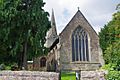
St Andrew's Church
The Anglican church, St Andrew's, is made of grey-green stone. The tower and north side were built in the 1200s. The church was made larger in the 1300s and 1400s. The tower has a special pointed roof called a broach spire. The main part of the church, called the chancel, built around 1300-1310, is taller and longer than the rest of the church.
St Edward the Confessor Church
The Roman Catholic church of St Edward the Confessor opened in 1922. Before this, people met in temporary places like a bake house or a room above a stable. The church was looked after by a group called the Dominicans until 1937.
Aylestone Baptist Chapel
The Baptists of Aylestone first met in a cottage in 1855. In 1869, they got a small brick building that could hold about 50 people. In 1871, they built the Aylestone Baptist Chapel. A new church and school building was built in 1932. The old church was sold in 1934 and became a clubhouse. It was later bought by the Apostolic Church in 1974.
Church of the Nativity
The Church of the Nativity, on Cavendish Road, is a combined Methodist and Anglican church. This means both groups share the church.
Sports in Aylestone
Aylestone has two local football teams. St Andrew's FC plays on Disraeli Street. Their local rivals, Aylestone Park F.C., play on Saffron Lane.
Images for kids
-
St Andrew's Church, Aylestone

