White Island (Otago) facts for kids
|
Māori: Ponuiahine
or 'Pomuiahine' |
|
|---|---|

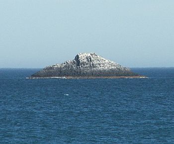
White Island, as seen from St. Clair Beach
|
|
| Geography | |
| Coordinates | 45°56′01″S 170°29′55″E / 45.933561°S 170.498572°E |
| Area | 1,600 m2 (17,000 sq ft) |
| Length | 80 m (260 ft) |
| Width | 30 m (100 ft) |
| Highest elevation | 15 m (49 ft) |
| Administration | |
| Demographics | |
| Population | 0 |
White Island is a small island located about 2,500 metres (2,700 yd) off the coast of Otago, in the city of Dunedin, South Island, New Zealand. No one lives on the island. It is a well-known sight that you can easily see from the city's two main beaches, St Clair and St Kilda.
The island is about 80 metres (87 yd) long and 30 metres (33 yd) wide at its widest point. It covers an area of 1,600 square metres (17,000 sq ft) and rises to a height of around 15 metres (49 ft). There is a rocky area, or reef, that stretches for 100 metres (110 yd) from the western side of the island. Parts of this rocky reef can be seen above the water when the tide is low.
What's in a Name?
The Māori name for White Island is Ponuiahine, sometimes also written as 'Pomuiahine'. People have tried to figure out what this name means. One idea is that it refers to a special post or memorial related to someone named Hine. It's important to remember that 'Hine' can be a name for both men and women.
Early Sightings
The Brothers Ship
White Island might be the place called 'Ragged Rock' that was visited by a ship named Brothers in November 1809. This ship was used for seal hunting and had a crew of eleven men. Three of these men were dropped off at 'Ragged Rock'. One of the men was William Tucker, who later settled nearby at Whareakeake (also known as Murdering Beach). Some people think 'Ragged Rock' could also have been Green Island.
The Rosanna and Lambton
On May 1, 1826, a man named Thomas Shepherd was on a ship called the Rosanna. He was traveling with another ship, the Lambton, as part of an expedition to start a new settlement in New Zealand. As they got closer to the coast, he wrote in his journal that he saw "two remarkable Sugar loaf Rocks in the sea near the shore about 100 feet (30 m) high."
A crew member went ashore and met a Māori man named Tatawa, who said he was from Otago. Shepherd later confirmed that he was talking about the coast near White Island. Today, there is a reef south of White Island where you can see the sea breaking. It's possible that in the 1820s, this reef also looked like a tall rock above the water. By the time the city of Dunedin was settled in 1848, only the single White Island was clearly visible.
 | Kyle Baker |
 | Joseph Yoakum |
 | Laura Wheeler Waring |
 | Henry Ossawa Tanner |

