White River (Yukon) facts for kids
Quick facts for kids White River |
|
|---|---|

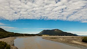
White River near Beaver Creek, Yukon
|
|
|
Location of the mouth of the White River in Yukon
|
|
| Countries |
|
| State/Territory | |
| Census Area | Valdez–Cordova in Alaska |
| Physical characteristics | |
| Main source | Russell Glacier Wrangell–St. Elias National Park and Preserve, Saint Elias Mountains, Alaska 4,258 ft (1,298 m) 61°40′18″N 141°50′01″W / 61.67167°N 141.83361°W |
| River mouth | Yukon River 12 miles (19 km) upstream of the mouth of the Stewart River, Yukon 2,129 ft (649 m) 63°11′24″N 139°35′23″W / 63.19000°N 139.58972°W |
| Length | 200 mi (320 km) |
The White River (also known as Rivière Blanche in French, and Tadzan ndek in the Hän language) is a river about 200 miles (320 km) long. It flows through parts of Alaska in the United States and Yukon in Canada. The White River is a tributary, meaning it's a smaller river that flows into a larger one. It eventually joins the much bigger Yukon River. You can even see the White River if you travel along the Alaska Highway near Beaver Creek.
Why the White River is "White"
The White River gets its name because of its unique color. It is a glacier-fed river, which means its water comes from melting glaciers. As glaciers move, they grind rocks into a very fine powder, almost like flour. This powder is called glacial flour or suspended sediment.
Sediment in the Water
The White River carries a huge amount of this fine rock powder. Each year, it transports about 19 million tons of sediment! This makes the water look cloudy and milky, giving the river its "white" appearance.
Impact on the Yukon River
When the White River flows into the Yukon River, it dramatically changes the Yukon's water clarity. The Yukon River then carries this sediment all the way to its mouth, staying cloudy for a very long distance.
See also
 | Calvin Brent |
 | Walter T. Bailey |
 | Martha Cassell Thompson |
 | Alberta Jeannette Cassell |


