
Whitehall Parkway facts for kids
The Whitehall Parkway is a large park in Whitehall Township, Lehigh County, Pennsylvania. It covers about 110 acres, which is like 110 football fields! This park is a special green area kept safe in the middle of the township. The local government bought the land in 1990 to protect its history. This history goes all the way back to the first settlers and includes stories about old cement and mining companies. The park is also home to the Coplay Creek, a small stream that flows into the bigger Lehigh River.
.JPG)
Contents
Park History: From Native Americans to Early Settlers
The land where Whitehall Parkway is today has a long and interesting past.
First People: The Lenni Lenape
Long ago, the first people to live on this land were the Lenni Lenape. They were a Native American tribe who lived in this area. A group of the Lenni Lenape, called the Minsi, lived along the Lehigh River. They used the land for hunting animals and fishing in the rivers. European settlers started arriving in the late 1600s and early 1700s.
The Walking Purchase: A Controversial Land Deal
William Penn, who Pennsylvania is named after, received a special paper from King Charles II of England. This paper said he owned Pennsylvania. But William Penn wanted to buy land fairly from the Native American tribes. He bought pieces of land from them over time.
After William Penn died, his son Thomas said that his father had another paper from the Lenni Lenape chiefs. This paper supposedly gave him as much land as a man could walk in one and a half days. This paper was never officially signed and is still debated today. However, the walk happened anyway! It started on September 19, 1737. This event is known as the Walking Purchase. It led to a huge amount of land being claimed, including parts of what are now Carbon, Lehigh, Monroe, and Northampton counties.
Early European Settlers and Fort Deshler
Just one week after the Walking Purchase, on September 26, 1737, two immigrants arrived. Their names were Johan Georg Kern and Georg Friedrich Newhardt. They came from a region in Germany called the Palatinate. On February 1, 1743, they bought 406 acres of land. This land included the area that is now Whitehall Parkway. They split the land evenly between them on November 30, 1744.
Newhardt later sold his part of the land to Adam Deshler. In 1760, Adam Deshler built a historic building called Fort Deshler on the site. People in the area say that soldiers used to be at the Fort. They supposedly protected local people who were running away from attacks by the Lenni Lenape tribes. However, there is no clear proof that soldiers were actually stationed there. It might have been a place where local families simply went to be safe during attacks. Kern later passed his land to his son. Eventually, the land was sold to cement companies. These companies played a big role in developing the area.
Whitehall Parkway Today: What You Can See
The Whitehall Parkway is a mix of nature and history.
Park Features and Activities
In 2005, official township papers described the park as having an old quarry, wet areas, a floodplain, and the remains of an old cement plant from the late 1800s or early 1900s.
Today, the township's website says that the park connects to the local Ironton Rail-Trail. This trail used to be train tracks but is now a path for walking and biking. The park also hosts a special event every June: a Civil War reenactment! This is where people dress up and act out battles from the American Civil War.
Local news also mentions a very old train car, called a caboose, near the park's western edge. It might be the second oldest caboose still around from the old Reading Railroad company!
Images for kids
-
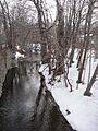
The Coplay Creek passes through the center of the Whitehall Parkway
