Whittington Tump facts for kids
Quick facts for kids Whittington Tump |
|
|---|---|
| Crookbarrow Hill | |

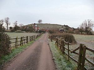
Whittington Tump and Crookbarrow Farm from the north-east
|
|
| Type | Remains of motte castle and manor house |
| Location | Worcestershire, England |
| OS grid reference | SO 87486 52286 |
| Official name: Motte castle, moated site, and medieval agricultural remains at Crookbarrow Farm | |
| Designated | 10 August 1923 |
| Reference no. | 1014900 |
| Lua error in Module:Location_map at line 420: attempt to index field 'wikibase' (a nil value). | |
Whittington Tump, also known as Crookbarrow Hill, is a special mound in Worcestershire, England. It's partly natural and partly built by people. This site has a long history, with signs of activity from prehistoric times. Some people even think the Romans built defenses here.
The area became important during the Anglo-Saxon period when a village was set up. Later, in the Middle Ages, a manor house was built nearby, and a motte castle stood on top of the hill. Today, the castle is gone, and the land is used for farming. Whittington Tump was officially protected as a scheduled monument in 1923.
Contents
What is Whittington Tump?
Whittington Tump is about 3 kilometers (2 miles) southeast of the city of Worcester. It sits on a hill that overlooks the southern approaches to the city. The hill rises 20 meters (66 feet) above the valley. It's shaped like an oval, measuring about 75 meters (246 feet) long and 40 meters (131 feet) wide.
People aren't completely sure how the hill was formed. However, many believe it's a natural hill that was made taller and steeper by human effort. This is especially true for the northern side. This idea has been around since the mid-1800s. The hill is covered in a reddish-brown clay soil.
The name "Whittington" comes from "Hwinton," which means a farm or enclosed area belonging to a man named White. The name "Crookbarrow" also comes from Old English.
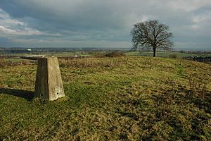
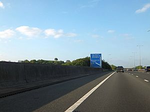
Today, the M5 motorway passes very close to the hill, about 150 meters (492 feet) away. Whittington Tump is easy to spot from the motorway because of a single tree on its top. Many drivers use it as a landmark when approaching Junction 7 (Worcester South).
A Look Back in Time

Early History and Roman Times
There's proof that people lived or visited Whittington Tump long ago. In 1886, a stone scraper from the Stone Age was found here. The hill would have been an important landmark even then. Some experts think it might have been a religious site or a burial mound in prehistoric times. Old Anglo-Saxon writings describe it as an ancient place.
About 300 meters (328 yards) south of the hill, archaeologists found a Roman-British settlement. This could have been a large farm, a small village, or a hamlet. Evidence shows people were working with iron and living there as early as the 2nd century AD. The site seems to have been abandoned by the 3rd or 4th centuries. Other Roman objects have been found on the northeast side of the tump.
Some old historians thought Whittington Tump was the burial place of a British leader named Caratacus. However, he likely died and was buried in Rome. In 1799, a historian named John Price suggested that the Romans had fortified the site.
Anglo-Saxon and Medieval Periods
It's believed that an Anglo-Saxon settlement, possibly belonging to the man named White, was built here by the 7th century AD. This spot was good for a settlement because it had fertile soil, water from Long Brook, and clear views of the surrounding land. Anglo-Saxon documents mention Whittington Tump as a well-known landmark. It was one of several Anglo-Saxon settlements in southern Worcestershire. It's even said that important laws passed in Middlesex were announced from Whittington Tump.
A medieval manor, called Crookbarrow Manor, is mentioned in a document from 1314. Its remains were found just east of the hill during archaeological digs before the M5 motorway was widened. This manor was likely used mainly for farming. It was about 45 meters (148 feet) square and surrounded by a moat. There's also evidence of medieval ridge and furrow farming to the north of the manor.
Archaeologists also think a motte castle stood on top of the hill during this time. A motte castle is a type of castle built on a raised earth mound. This castle might have had a wooden or stone tower. Terraces on the north and west sides suggest it was surrounded by a fence or walkway. Square dips on the top of Whittington Tump show where structures, about 3 to 4 meters (10 to 13 feet) wide, once stood. After the castle was no longer used, the motte was used for farming. You can still see the remains of this farming on the north and west sides of the hill.
Modern Times
From the 17th century, Crookbarrow Farm was built on the southwest part of the old manor site. Because the area has been used for farming for so long, an earth bank, called a lynchet, has formed at the base of the hill. This is very clear on the west and southwest sides. In some places, trees have been planted on this bank, and it's used as a field boundary. Parts of the old manor house moat still exist as a ditch, up to 10 meters (33 feet) wide and 2.5 meters (8 feet) deep.
The entire site, including the "motte castle, moated site, and medieval agricultural remains," was protected as a scheduled monument on August 10, 1923. This was because the castle is a good example of a motte structure. The tump might also hold clues about how it was originally built, like old post holes or foundations. The site is important because it helps us understand the political and social life in Worcestershire during the Middle Ages.
In 1948, a triangulation pillar was placed on top of the tump. This pillar is used for surveying and mapping.


