Wieringermeer facts for kids
Quick facts for kids
Wieringermeer
|
|||
|---|---|---|---|
|
Former municipality
|
|||

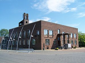
Town hall
|
|||
|
|||
 |
|||
| Country | Netherlands | ||
| Province | North Holland | ||
| Municipality | Hollands Kroon | ||
| Area
(2006)
|
|||
| • Total | 307.76 km2 (118.83 sq mi) | ||
| • Land | 194.82 km2 (75.22 sq mi) | ||
| • Water | 112.94 km2 (43.61 sq mi) | ||
| Population
(1 January 2007)
|
|||
| • Total | 12,676 | ||
| • Density | 65/km2 (170/sq mi) | ||
| Source: CBS, Statline. | |||
| Time zone | UTC+1 (CET) | ||
| • Summer (DST) | UTC+2 (CEST) | ||
| Website | www.wieringermeer.nl | ||
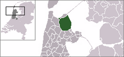
Wieringermeer is a special kind of land called a polder in the Netherlands. It used to be its own municipality, which is like a local government area. This area is located in the province of North Holland. Since 2012, Wieringermeer has become part of a larger municipality called Hollands Kroon.
Contents
Towns and Villages
The area that used to be the municipality of Wieringermeer includes several small towns and villages. These are Kreileroord, Middenmeer, Slootdorp, and Wieringerwerf.
History of Wieringermeer
From Land to Lake and Back
Around the year 1000 AD, the area where Wieringermeer is now was dry land. But after 1100, big storms hit, turning it into a flood plain. This meant it was often covered by water. The name "Wieringermeer" actually means "Wieringen Lake." This was the name of the inland lake that filled the area during the early Middle Ages.
Creating New Land
The Wieringmeerpolder is a polder, which means it's new land that was created by draining water. It's part of a huge project from the 20th century called the Zuiderzee Works. This project aimed to reclaim land from the sea. The plan was to create this polder after a big dam called the Afsluitdijk was finished. However, there was a great need for more farming land, so building the polder started earlier, in 1927.
The dikes, which are strong walls, had to be built very well to hold back the powerful water of the Zuiderzee. The draining of the polder was completed on August 21, 1930. After the Afsluitdijk was finished in 1932, the Zuiderzee turned into a freshwater lake called IJsselmeer.

Developing the Polder
After the land was drained, it was still salty from the sea. It needed to be "desalinized," which means the salt had to be removed. Once the land was no longer salty, it became ready for use in 1934. Four villages were built in the polder: Slootdorp (in 1931), Middenmeer (in 1933), Wieringerwerf (in 1936), and Kreileroord (in 1957).
On July 1, 1941, Wieringermeer became its own independent municipality.
The World War II Flood
During the Second World War, on April 17, 1945, something dramatic happened. The German soldiers who were occupying the area ordered the dike of the Wieringermeer to be blown up. This caused the entire area to be flooded again. This event is known as the Inundation of the Wieringermeer.
Luckily, everyone living there was warned beforehand. So, as the polder slowly filled with water, no one was hurt or killed. However, the high water and a later storm destroyed most of the buildings and roads that had been built over the past decade. The good news was that the floodwater was fresh water, not salty seawater. This meant the land did not need to be desalinized again.
Rebuilding started very quickly. By the end of 1945, the polder was drained once more. Rebuilding roads, bridges, houses, and farms was much easier this time. People had learned a lot from building everything the first time.
See also
 In Spanish: Wieringermeer para niños
 | Georgia Louise Harris Brown |
 | Julian Abele |
 | Norma Merrick Sklarek |
 | William Sidney Pittman |


