Wilcowie, South Australia facts for kids
Quick facts for kids WilcowieSouth Australia |
|||||||||||||||
|---|---|---|---|---|---|---|---|---|---|---|---|---|---|---|---|
 |
|||||||||||||||
| Postcode(s) | 5432 | ||||||||||||||
| Location | 35 km (22 mi) south-west of Carrieton | ||||||||||||||
| LGA(s) | Pastoral Unincorporated Area | ||||||||||||||
| State electorate(s) | Stuart | ||||||||||||||
| Federal Division(s) | Grey | ||||||||||||||
|
|||||||||||||||
| Footnotes | Coordinates | ||||||||||||||
Wilcowie is a quiet countryside area in the Far North region of South Australia. It's known as a "rural locality," meaning it's a place with farms and open spaces, not a busy city. Wilcowie is located within the Pastoral Unincorporated Area of the state. This special area doesn't have its own local council.
About Wilcowie
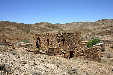
The name Wilcowie and its boundaries were officially chosen on April 26, 2013. The area was named after a large, old farming property called the Wilcowie pastoral property. Today, you can still see the ruins of the old Wilcowie Homestead, which was once the main house on this property.
Historic Places
Prince Alfred Copper Mine
One important historical site in Wilcowie is the Prince Alfred Copper Mine Precinct. This area is very old and has been officially listed on the South Australian Heritage Register. This means it's a special place that is protected because of its history. You can visit this mine area by taking Prince Alfred Road.
The Prince Alfred Mine was once a busy place where people dug for copper. A Post Office even opened there on July 13, 1872, to serve the miners and their families. However, the Post Office closed a few years later, on April 1, 1876, as the mining activity changed.
 | John T. Biggers |
 | Thomas Blackshear |
 | Mark Bradford |
 | Beverly Buchanan |


