Willard-Hay, Minneapolis facts for kids
Quick facts for kids
Willard-Hay
|
|
|---|---|
|
Neighborhood
|
|
 |
|
| Nickname(s):
Willard-Homewood
|
|

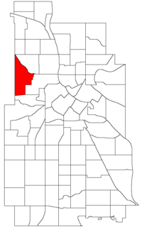
Location of Willard-Hay within the U.S. city of Minneapolis
|
|
| Country | United States |
| State | Minnesota |
| County | Hennepin |
| City | Minneapolis |
| Community | Near North |
| City Council Wards | 4, 5 |
| Area | |
| • Total | 1.068 sq mi (2.77 km2) |
| Population
(2020)
|
|
| • Total | 8,942 |
| • Density | 8,373/sq mi (3,232.7/km2) |
| Time zone | UTC-6 (CST) |
| • Summer (DST) | UTC-5 (CDT) |
| ZIP code |
55411
|
| Area code(s) | 612 |
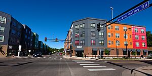
Willard-Hay is a friendly neighborhood located in the northwest part of Minneapolis, a big city in the United States. People often call this area the "Northside." It is part of a larger area known as the Near North community.
Many residents know the neighborhood as Willard-Homewood. The southern part, below Plymouth Avenue, is specifically called Homewood. The neighborhood gets its name from two elementary schools within its borders: Frances Willard and John Hay.
Contents
Understanding the Population
| Historical population | |||
|---|---|---|---|
| Census | Pop. | %± | |
| 1980 | 8,678 | — | |
| 1990 | 8,409 | −3.1% | |
| 2000 | 9,277 | 10.3% | |
| 2010 | 8,611 | −7.2% | |
| 2020 | 8,942 | 3.8% | |
Demographics help us understand the people living in a certain area. This includes how many people live there and how the population has changed over time.
Willard-Hay's Population Count
The population of Willard-Hay has changed over the years. Here is a look at the number of people living in the neighborhood during different census years:
- 1980: 8,678 people
- 1990: 8,409 people
- 2000: 9,277 people
- 2010: 8,611 people
- 2020: 8,942 people
Exploring Willard-Hay's Location
The Willard-Hay neighborhood has clear boundaries that help define where it is. Knowing these boundaries helps you understand its exact location within Minneapolis.
Neighborhood Borders
The neighborhood's edges are:
- To the south: Olson Memorial Highway.
- To the east: Penn Avenue (though a small part is northeast of Penn and Plymouth).
- To the northeast: Broadway Avenue.
- To the west: Theodore Wirth Park.
Local Government and Representation
Willard-Hay is mostly in Ward 5. A "ward" is like a section of a city. This ward is represented by a City Council member named Jeremiah Ellison.
A smaller part of the neighborhood, in the northwest (north of 26th Avenue), is in Ward 4. This area is represented by Council Member LaTrisha Vetaw. These council members work to make decisions for the city and help their neighborhoods.
The neighborhood is also part of a larger area for state government. It is in Legislative District 59B. This district is represented by State Senator Bobby Joe Champion and State Representative Esther Agbaje.
The Homewood Historic District
Within Willard-Hay, you'll find the Homewood Historic District. This special area is important because of its history. It is bordered by:
- Plymouth Avenue to the north.
- Penn Avenue to the east.
- Oak Park Avenue to the south.
- Xerxes Avenue to the west.
This district became a historic site on February 28, 2017. It was a central place for the Jewish community on the North Side starting in the early 1910s. This designation helps protect the area's unique history and buildings.
 | Mary Eliza Mahoney |
 | Susie King Taylor |
 | Ida Gray |
 | Eliza Ann Grier |

