Wind River (Washington) facts for kids
Quick facts for kids Wind River |
|
|---|---|

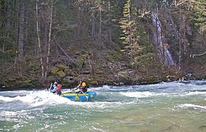
Rafting the Wind River
|
|
|
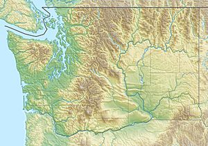
Location of the mouth of the Wind River in Washington
|
|
| Country | United States |
| State | Washington |
| Physical characteristics | |
| Main source | Cascade Range McLellan Meadows, Gifford Pinchot National Forest 2,987 ft (910 m) 46°00′11″N 121°53′48″W / 46.00306°N 121.89667°W |
| River mouth | Columbia River Carson 79 ft (24 m) 45°42′47″N 121°47′37″W / 45.71306°N 121.79361°W |
| Length | 30 mi (48 km) |
| Depth |
|
| Basin features | |
| Basin size | 224 sq mi (580 km2) |
The Wind River is a cool river in the state of Washington, United States. It's a tributary of the mighty Columbia River. This means it's a smaller river that flows into a larger one.
The Wind River is about 30 miles (48 km) long. Its entire journey happens within Skamania County. Long ago, some people called it the Crusattes River.
Where Does the Wind River Flow?
The Wind River starts high up in the Cascade Range mountains. This is a big mountain range in the western part of North America. Its source is south of two famous volcanoes: Mount Adams and Mount St. Helens.
Journey Through the Forest
From its start, the river generally flows south. It winds its way through the beautiful Gifford Pinchot National Forest. This forest is known for its tall trees and amazing nature.
Joining the Columbia River
Finally, the Wind River reaches its end. It flows into the Columbia River near a town called Carson. This meeting point is inside the stunning Columbia River Gorge. The gorge is a huge canyon carved by the Columbia River.
 | Percy Lavon Julian |
 | Katherine Johnson |
 | George Washington Carver |
 | Annie Easley |


