Wittmund (district) facts for kids
Quick facts for kids
Wittmund
|
|||
|---|---|---|---|
|
|||
| Country | |||
| State | Lower Saxony | ||
| Capital | Wittmund | ||
| Area | |||
| • Total | 656.65 km2 (253.53 sq mi) | ||
| Time zone | UTC+1 (CET) | ||
| • Summer (DST) | UTC+2 (CEST) | ||
| Vehicle registration | WTM | ||
| Website | landkreis.wittmund.de/ | ||
Wittmund is a district, which is like a region, located in the northwest of Lower Saxony, a state in Germany. It's part of a special area called East Frisia, right on the coast of the North Sea.
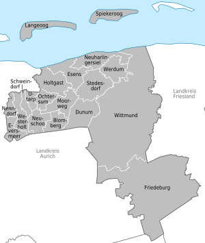
This district is home to a part of the Wadden Sea, which is a unique natural area. It also includes a section of the Lower Saxony Wadden Sea National Park. Two beautiful islands, Langeoog and Spiekeroog, are also part of the Wittmund district. These islands are famous East Frisian Islands.
Contents
Towns and Villages in Wittmund
The Wittmund district is made up of several towns and many smaller villages. These are organized into different types of groups to help manage them.
There are some towns and villages that are managed on their own. Others are grouped together into what are called Samtgemeinden. A Samtgemeinde is like a collection of smaller towns and villages that work together on some things. Each still has its own local council.
Here are the main towns and groups of villages in the Wittmund district:
Main Town
- Wittmund
Independent Villages
- Friedeburg
- Langeoog (This is one of the islands!)
- Spiekeroog (This is the other island!)
Groups of Villages (Samtgemeinden)
- 1. Esens
- Dunum
- Esens (This is the main town of this group)
- Holtgast
- Moorweg
- Neuharlingersiel
- Stedesdorf
- Werdum
- 2. Holtriem
- Blomberg
- Eversmeer
- Nenndorf
- Neuschoo
- Ochtersum
- Schweindorf
- Utarp
- Westerholt (This is the main town of this group)
See also
 In Spanish: Distrito de Wittmund para niños
 | Georgia Louise Harris Brown |
 | Julian Abele |
 | Norma Merrick Sklarek |
 | William Sidney Pittman |


