Woolsey, Georgia facts for kids
Quick facts for kids
Woolsey, Georgia
|
|
|---|---|

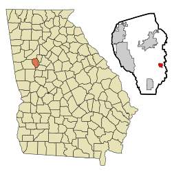
Location in Fayette County and the state of Georgia
|
|
| Country | United States |
| State | Georgia |
| County | Fayette |
| Area | |
| • Total | 0.84 sq mi (2.18 km2) |
| • Land | 0.82 sq mi (2.12 km2) |
| • Water | 0.02 sq mi (0.06 km2) |
| Elevation | 837 ft (255 m) |
| Population
(2020)
|
|
| • Total | 206 |
| • Density | 251.83/sq mi (97.25/km2) |
| Time zone | UTC-5 (Eastern (EST)) |
| • Summer (DST) | UTC-4 (EDT) |
| ZIP code |
30215
|
| Area code(s) | 770 |
| FIPS code | 13-84288 |
| GNIS feature ID | 0333466 |
Woolsey is a small town located in Fayette County, Georgia, in the United States. In 2020, about 206 people lived there. It's a quiet place in the southeastern part of Fayette County.
Woolsey's Past: A Brief History
Woolsey became an official town in 1893. This happened when the Georgia General Assembly (which is like Georgia's state government lawmakers) decided to make it a town. Woolsey got its name from a well-known doctor. This doctor served in the Confederacy (a group of southern states during the American Civil War) before he was injured.
Where is Woolsey Located?
Woolsey is found in the southeastern part of Fayette County. You can find it at these coordinates: 33°21′48″N 84°24′29″W / 33.36333°N 84.40806°W. It is also located along Georgia State Route 92.
The county seat (the main town where the county government is) is Fayetteville. Fayetteville is about 7 miles (11 km) north of Woolsey. Another town, Griffin, is about 18 miles (29 km) to the southeast.
The United States Census Bureau measures land and water areas. They say Woolsey covers a total area of about 2.18 square kilometers (0.84 square miles). Most of this area, about 2.12 square kilometers (0.82 square miles), is land. The rest, about 0.06 square kilometers (0.02 square miles), is water. This means about 2.76% of Woolsey's total area is water.
Who Lives in Woolsey?
This section talks about the people who live in Woolsey. It's called demographics.
| Historical population | |||
|---|---|---|---|
| Census | Pop. | %± | |
| 1910 | 162 | — | |
| 1920 | 148 | −8.6% | |
| 1930 | 122 | −17.6% | |
| 1940 | 115 | −5.7% | |
| 1950 | 90 | −21.7% | |
| 1960 | 114 | 26.7% | |
| 1970 | 91 | −20.2% | |
| 1980 | 99 | 8.8% | |
| 1990 | 120 | 21.2% | |
| 2000 | 175 | 45.8% | |
| 2010 | 158 | −9.7% | |
| 2020 | 206 | 30.4% | |
| U.S. Decennial Census | |||
In the year 2000, there were 175 people living in Woolsey. These people lived in 57 different homes, and 49 of those homes were families. By the year 2020, the number of people living in Woolsey grew to 206.
In 2000, the median income for a household in Woolsey was $84,103. This means that half of the households earned more than this amount, and half earned less. For families, the median income was $83,224.
Men had a median income of $76,250, while women had a median income of $62,813. The per capita income (which is the average income per person) for the town was $42,177.
About 4.5% of families and 3.0% of all people in Woolsey lived below the poverty line. This means their income was below a certain level set by the government. This included 4.2% of young people under 18. No one aged 65 or older was found to be below the poverty line in 2000.
See also
 In Spanish: Woolsey (Georgia) para niños
 | Stephanie Wilson |
 | Charles Bolden |
 | Ronald McNair |
 | Frederick D. Gregory |

