
Woolston, New Zealand facts for kids
Quick facts for kids
Woolston
|
|
|---|---|
|
Suburb
|
|

Christchurch from the Port Hills; Woolston is the northern part of the industrial area in the foreground
|
|

Woolston
Location in New Zealand
|
|
| Country | New Zealand |
| Local authority | Christchurch |
| Electoral ward |
|
| Area | |
| • Land | 636 ha (1,572 acre) |
| Population
(June 2023)
|
|
| • Total | 10,890 |
|
|
||
Woolston is a busy suburb in Christchurch, located on the South Island of New Zealand. It's a mix of homes and light industries, meaning there are factories and businesses that make things. Woolston is about three kilometres southeast of the main city centre. It's also close to important roads like State Highways 74 and 76, which lead to Banks Peninsula. The Ōpāwaho / Heathcote River flows right through the suburb.
Contents
Woolston's Past: A Look Back in Time
Early Days and Māori History
Before Europeans arrived, the area we now call Woolston wasn't a clearly named place. The muddy areas at Ferrymead, which are at the eastern end of Woolston today, were very important to the local Ngāi Tahu people. They used this spot, called "Ohika paruparu" in Māori, to gather shellfish and other food. This is the only Māori name known for this specific area before European settlers came.
The western part of Woolston was known as Roimata by early Europeans. Roimata means "teardrop" in Māori. Even today, some land records in this area still use the name Roimata. Recently, groups like the Roimata Community Inc. have started using the name again. These groups work to help the community in the Roimata area. This area is generally found between Ensors Road, Brougham Street, Ferry Road, and Richardson Terrace.
The First Church and Growing Community

One of the first signs that a European community was growing in Woolston was the building of a church. This was the Anglican Parish of St John the Evangelist Woolston. The first church building, made of cob (a mix of clay and straw), was built in 1857. A new timber (wood) church replaced it in 1882. The current concrete church building was finished in 1960. This church is still used daily and is open to the public on Sundays. It's located on Ferry Road. The parish itself is one of the oldest Anglican parishes in New Zealand.
From Lower Heathcote to Woolston
Woolston was once part of the Heathcote County Council. In the 1850s and 1860s, small ships used wharves along the Ōpāwaho / Heathcote River. They brought goods to the area. Before the Lyttelton Rail Tunnel opened in 1867, all trade coming into Christchurch arrived at Ferrymead. These goods were then transported through Woolston, along Ferry Road, into Christchurch. This made the area quite busy. After the tunnel opened, Woolston became even more industrial. Ferry Road later had tramlines that went to Sumner.

Until the early 1870s, the area was often called Lower Heathcote. But during a meeting about a drain, a local shop owner named Joseph Harry Hopkins suggested a new name. He named the area Woolston after his hometown, Woolston in Southampton, England. On June 16, 1870, the name Woolston was officially approved for the post office. Woolston became its own self-governing town in 1882. It stayed that way until 1921, when it joined Christchurch City.
The Woolston Cut: Managing the River

The Ōpāwaho / Heathcote River was very important for industries in Woolston. Businesses like wool scouring, which cleans wool, needed a lot of water. Over time, the river became very polluted. To help with this, a special sewer for industries was built in 1966.
Flooding was also a big problem. In 1986, work began on the Woolston Cut. This was a channel built to let floodwaters bypass a long bend in the river. The project cost about NZ$2 million. However, it also caused some problems. Trees along the riverbank died, and the riverbanks themselves collapsed in some places. Even with the Cut, the Heathcote River still flows through its original bend, which is called the Woolston Loop, during normal times.
Woolston Today: A Hub of Activity

Woolston's location near the Lyttelton rail line has kept it a great place for businesses. Over the years, it became a major centre for New Zealand's rubber industry. Other factories, like a nugget factory and a glue works, also grew here. Many of these businesses are still around today. Woolston is also home to Christchurch's largest container terminal, where big shipping containers are handled.

More and more homes have been built in Woolston over time. Now, it's fully connected with Christchurch City. People who study New Zealand's history say that Woolston has a strong "working-class identity." This means many factory workers lived there, creating a close-knit community.
Woolston is also known for its local groups. It has an indoor football team called The Woolston Drivebys. The Woolston Brass Band, which started in 1891, is very famous in New Zealand and has won many awards.
Historic Buildings in Woolston
Before the big 2011 Christchurch earthquake, several old buildings in Woolston were listed as important heritage sites. Here are a few:
- A & T Burt building: This was once the Nugget Boot Polish Factory, built in 1924. Sadly, it was badly damaged in the 2011 earthquake and had to be taken down.
- Bloomsbury: This is a large old house located at 37 Maunsell Street.
- Jubilee Hospital: This hospital for the elderly and sick was built in 1888. It closed in 1990, and some parts were demolished. Today, the remaining buildings are used as a fish processing plant.
- Stone Cottage: Built in 1863 from local stone, this cottage is now a restaurant and catering service called Dizzy Lizzy's.
- Whalebone Cottage: Built around 1867, this cottage used to have an arched gateway made from whale ribs! Those bones are no longer there, but the cottage remains.
- Woolston Borough Monument: This monument dates back to 1893.
Economy: Businesses and Shops
The Tannery is a popular shopping and entertainment spot that opened in Woolston in 2013. It has about 60 different stores, including a cinema where you can watch movies.
Education: Schools in Woolston
Woolston has several schools for students from Year 1 to Year 8.
- Ngutuawa School and Te Waka Unua School are full primary schools. Ngutuawa started as Bamford School in 1952. It was damaged in the Christchurch earthquakes and moved to a new site with its new name in 2020. Te Waka Unua opened in 2015 after two other schools, Phillipstown School and Woolston School, joined together.
- St Anne's Catholic School and Tamariki School are state-integrated primary schools. This means they are private schools that also get some government funding. St Anne's was built in 1906. Tamariki School opened in 1966 and teaches students using special principles from a famous educator named A. S. Neill.
- Kimihia Parents' College is a special unit of Linwood College for teenage parents.
All these schools, except Kimihia Parents' College, teach both boys and girls.
Images for kids
-

Christchurch from the Port Hills; Woolston is the northern part of the industrial area in the foreground
-
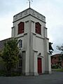
The bell tower, St John the Evangelist Woolston
-
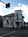
The Old Ferry Road/Woolston Post Office
-
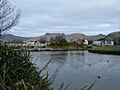
The Woolston Tidal Barrage and the Woolston Cut
-
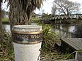
Union Wharf memorial bollard in Catherine Street, Woolston
-
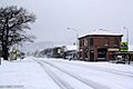
Woolston during the 2011 New Zealand snowstorms
