Worsley Navigable Levels facts for kids
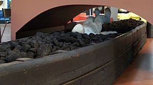
The Worsley Navigable Levels are a huge network of underground tunnels and canals. They are located in Worsley, a town in Greater Manchester, England. These tunnels were built inside coal mines. They helped miners get coal out and kept the mines from flooding. Special boats called starvationers were used to move coal through these underground waterways.
Contents
The Start of Coal Mining in Worsley
People have been digging for coal in the Worsley area since at least 1376. But the mines really grew much later. This happened when Francis Egerton, the 3rd Duke of Bridgewater, took charge.
In 1729, the first big drainage tunnel was dug. It was called a sough. This sough was built on the Duke of Bridgewater's land in Worsley. It was part of the Manchester Coalfield. The sough was 1,100 yards (1,000 m) long, with 600 yards (550 m) of it underground. Its main job was to drain water from the mines.
Water from the coal layers above the sough flowed into it. This made it easier to mine deeper coal. Miners only needed to pump water up to the sough, not all the way to the surface. This plan worked very well. More sections were added, making the sough 450 yards (410 m) longer. This helped drain even more coal seams.
A New Duke and Big Ideas
In 1748, Francis Egerton became the 3rd Duke of Bridgewater. He was only 21 when he took full control of his estates in 1757. He hired a smart manager named John Gilbert.
Francis Egerton and John Gilbert saw that the demand for coal in Manchester was growing fast. They knew the Duke's coal mines needed to be much more efficient. Their first idea was to build a canal. This canal, called the Bridgewater Canal, would go from Worsley to Salford on the River Irwell. This would make transporting coal much easier.
But they had an even bigger idea. They decided to extend the canal underground. This would create a navigable level right inside the coal mines. It would help drain water and transport coal at the same time. A great benefit was that the water from the mines was enough to keep the canal full.
Building the Bridgewater Canal and Underground Levels
The law allowing the Bridgewater Canal to be built passed in 1759. Work on the canal had already started when James Brindley joined the project. Brindley became the main engineer for the canal. He made some changes to its path. The canal was finished in 1764.
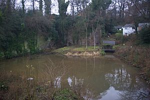
Even before the canal was done, work on the underground navigable level began. A tunnel 8 feet (2.4 m) high was dug north from the canal at Worsley. It had 4 feet (1.2 m) of space above the water and 4 feet (1.2 m) of water depth. In 1761, they reached the first usable coal seam. This was 770 yards (700 m) from the tunnel's entrance.
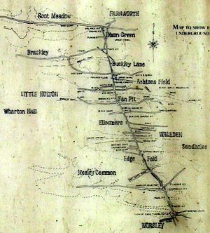
The tunnel was not straight. It curved to avoid digging under other people's land. As they found new coal seams, they dug branch tunnels into them. These branches grew longer as more coal was mined. The branch along the Four Feet seam alone reached 1.75 miles (2.8 km) in length.
Miners also dug shafts and mined coal ahead of the main tunnel. The main navigable level kept getting longer for many years. It eventually reached a length of 4 miles (6.4 km). So many boats used the level that it became crowded. To fix this, a second entrance tunnel was dug. It was 500 yards (460 m) long. A one-way system was then put in place to manage traffic.
In 1773, an upper navigable level was created. This was done by making the original drainage sough wider. It ended up being 1.75 miles (2.8 km) long. Water from this upper level drained into the main navigable level.
A sloped branch was also built from the upper level to the surface. It had a steep slope of 1 in 4. This allowed boats to be pulled up and lowered down. Later, this slope was extended downwards to the main level. Even more navigable levels were dug below the main level. These reached depths of 57 yards (52 m) and 83 yards (76 m) deeper to reach more coal.
The Underground Incline
Before 1797, coal was moved between different levels using vertical shafts. But then, an amazing underground canal inclined plane was finished. Work on it had started in 1795. This incline was 453 feet (138 m) long. It lifted boats 106 feet 6 inches (32.46 m) up or down.
At the upper level, there were two locks. From these locks, two railway tracks went down to the lower main level. Boats would enter the upper locks and sit on special wagons. The water was then drained from the locks. The boats would slide down the incline. An empty boat going up on the parallel track would balance their weight.
This clever incline worked until 1822. The navigable levels were used for transporting coal until 1887. By then, the total length of these underground canals was an incredible 46 miles (74 km). Even after coal transport stopped, the levels were still used for drainage. They were regularly inspected by boat until they finally closed in 1968.
 | May Edward Chinn |
 | Rebecca Cole |
 | Alexa Canady |
 | Dorothy Lavinia Brown |


