Wyandotte, Oklahoma facts for kids
Quick facts for kids
Wyandotte, Oklahoma
|
|
|---|---|
| Motto(s):
"Preserving The Future Of Our Past"
|
|

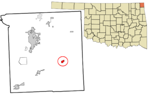
Location within Ottawa County and Oklahoma
|
|
| Country | United States |
| State | Oklahoma |
| County | Ottawa |
| Area | |
| • Total | 1.36 sq mi (3.52 km2) |
| • Land | 1.36 sq mi (3.52 km2) |
| • Water | 0.00 sq mi (0.00 km2) |
| Elevation | 768 ft (234 m) |
| Population
(2020)
|
|
| • Total | 488 |
| • Density | 358.82/sq mi (138.56/km2) |
| Time zone | UTC-6 (Central (CST)) |
| • Summer (DST) | UTC-5 (CDT) |
| ZIP code |
74370
|
| Area codes | 539/918 |
| FIPS code | 40-82250 |
| GNIS feature ID | 2413515 |
Wyandotte is a small town located in Ottawa County, Oklahoma, in the United States. In 2020, about 488 people lived there. The town is named after the Wyandotte Nation of Oklahoma, and it is where their tribal headquarters are located.
Contents
History of Wyandotte

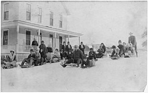
The Wyandotte tribe moved to this area in 1867. A group called the Society of Friends, also known as Quakers, started a mission here in 1869. The Wyandotte Tribal Council gave land to the Quakers to build a boarding school. This school was for children from the Seneca, Shawnee, and Wyandotte tribes.
Building the school began in 1871, and classes started in 1872. The town was first called Prairie City. However, its post office was renamed to Wyandotte in 1894, which is the town's current name.
In the mid-1920s, Wyandotte became famous for having an all-female city government. This happened after the Nineteenth Amendment was passed, which gave women the right to vote. Mamie Foster was the mayor during this time. She was Oklahoma's first female mayor and served for over five years.
In the late 1930s, the government built the Pensacola Dam. This dam created a large lake called Grand Lake o' the Cherokees. Even though the lake covered some of Wyandotte's land, it brought new businesses. More homes were built, and tourism grew, which helped the town's population increase again.
In 1966, town officials found out that Wyandotte had never officially become an incorporated town. This means they hadn't completed the legal paperwork to be recognized as a city. They asked the Ottawa County Board of Commissioners for an election. Most people voted for the town to become officially incorporated, which happened in April 1966.
Geography
Wyandotte is located about 12 miles (19 km) southeast of Miami.
The town covers an area of about 0.5 square miles (1.3 km2), and all of it is land.
Population Information
| Historical population | |||
|---|---|---|---|
| Census | Pop. | %± | |
| 1900 | 224 | — | |
| 1910 | 255 | 13.8% | |
| 1920 | 274 | 7.5% | |
| 1930 | 271 | −1.1% | |
| 1940 | 348 | 28.4% | |
| 1950 | 242 | −30.5% | |
| 1960 | 226 | −6.6% | |
| 1970 | 297 | 31.4% | |
| 1980 | 336 | 13.1% | |
| 1990 | 356 | 6.0% | |
| 2000 | 363 | 2.0% | |
| 2010 | 333 | −8.3% | |
| 2020 | 488 | 46.5% | |
| U.S. Decennial Census | |||
Wyandotte is part of the larger Joplin, Missouri metropolitan area.
In 2000, there were 363 people living in Wyandotte. About 35.5% of the population was under 18 years old. The median age was 32 years.
Education
Wyandotte Public Schools provides education for the town and nearby areas. They have elementary, middle, and high schools. The entire town is within this school district.
Oklahoma D-Day Event
Every June, Wyandotte hosts one of the biggest scenario paintball games in the world. Up to 5,000 players come to participate each year. The game takes place at the D-Day Adventure Park. This is a private park with 740 acres (300 km2) of thick woods.
Places to Visit
- Grand Lake o' the Cherokees is a large lake created by the Pensacola Dam. It is fed by three rivers: the Neosho, Spring, and Elk Rivers. The lake covers 59,000 acres (239 km2) and has 1,300 miles (2,100 km) of shoreline. It is a popular spot for fishing, boating, and other water sports. You can learn more at Grand Lake `O Cherokees.
- Twin Bridges State Park is located west of Wyandotte. It sits where the Neosho and Spring Rivers meet. The park offers boat access to Grand Lake, fishing, camping, and other fun activities.
Transportation
Highways
Wyandotte is served by US-60, a major highway.
Railroads
The Burlington Northern & Santa Fe Railway (BNSF) Cherokee Subdivision train line runs through Wyandotte. This railway connects Springfield, Missouri to the east with Tulsa, Oklahoma to the west.
See also
 In Spanish: Wyandotte (Oklahoma) para niños
 | Roy Wilkins |
 | John Lewis |
 | Linda Carol Brown |

