Wyke Beck facts for kids
Quick facts for kids Wyke Beck |
|
|---|---|

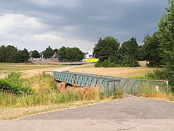
Footbridge over the Wyke Beck
|
|
| Country | England |
| County | West Yorkshire |
| City | Leeds |
| Physical characteristics | |
| Main source | Waterloo Lake Roundhay Park, Leeds 490 feet (150 m) 53°49′52″N 1°29′35″W / 53.831°N 1.493°W |
| River mouth | River Aire Skelton Lake 66 feet (20 m) 53°45′58″N 1°28′30″W / 53.766°N 1.475°W |
| Length | 6.2 miles (10 km) |
The Wyke Beck is a stream that flows through east Leeds, West Yorkshire, England. It starts in Roundhay Park and ends in the River Aire. People call it an Urban Beck because it flows through neighborhoods and industrial areas.
The Wyke Beck has often flooded in the past. Because of this, Leeds City Council has started projects to manage its flow and store floodwater. This helps protect homes and businesses. The beck is also like a green pathway through Leeds. It flows near or through five special nature areas called local nature reserves.
Contents
What is the Wyke Beck?
The Wyke Beck begins as water flowing out of Waterloo Lake. This lake is in Roundhay Park, Leeds. Waterloo Lake is quite large, covering about 33 acres. It is also very deep, reaching 60 feet in some places.
Long ago, the lake area was a quarry. It was turned into a park feature by soldiers who had returned from wars. That is why it is called Waterloo Lake.
Where Does Wyke Beck Flow?
The beck flows south from the lake. It goes under the A58 road and through an area called Gipton. Then it passes under the A64 road and the Leeds to York Railway Line. It also flows around the western side of Primrose Valley park.
Further south, the beck flows through an industrial area. In the past, this area caused pollution in the beck. For example, the site of Meadowfield Primary School was once a coal mine called Wyke Beck Colliery until 1951.
The path of the water was changed in 1914. This happened when a sewage treatment plant opened at Knostrop. There are plans to change the beck's path again. This is for a new train depot for HS2 trains. The beck used to flow through what is now Skelton Lake. The River Aire was straightened at some point, and the beck was moved to join the river a bit further south.
Why Does Wyke Beck Flood?
The Wyke Beck is an important stream that feeds into the River Aire. It has flooded many times, especially in 2004, 2005, and 2007. Flooding happens for a few reasons. Heavy rain is the main cause.
Other reasons include trash dumped into the stream. Also, buildings built too close to or over the beck can make flooding worse. Yorkshire Water has put in special tanks. These tanks help stop floodwater and waste from entering the beck during heavy storms.
Past Flooding Events
In August 2008, the water level in the beck rose very quickly. It went up by 1 meter in just 15 minutes! Firefighters had to pump water away from the A64 road. In 2017, flooding reached 1.7 meters on the Dunhills Estate. Sirens were used to warn people about the rising water. The highest water level ever recorded at Gipton was 1.99 meters in June 2007.
Fun Along the Wyke Beck
The Wykebeck Way is a path that follows the beck south. It goes all the way to Temple Newsam. The beck flows through or next to five special nature areas. These are Wykebeck Woods and Asket Hill, Arthur’s Rein, Killingbeck Fields, Primrose Valley, and Halton Moor.
In 2017, a new bridge was built called Skelton Bridge. This bridge connects the Wyke Beck Way to Rothwell Country Park. It crosses both the River Aire and the Aire and Calder Navigation.
Protecting Against Floods
Flooding from the Wyke Beck has caused problems for homes near Killingbeck Meadows Local Nature Reserve. So, in 2019, a project started to control floods there. This project helps store floodwater at Killingbeck Meadows. It was part of a larger £4.75 million plan to improve the local environment.
More plans were made in May 2020 to build dams and wetlands in the Killingbeck nature reserve. The flood area at Killingbeck fields can hold 25,000 cubic meters of water. With the new plans, this could increase to 45,000 cubic meters.
Wyke Beck's Wildlife
The water in Wyke Beck is rated as "Moderate" for its natural health. However, its chemical quality is "Good." In the early 2010s, the beck's chemical quality was not good enough. The Environment Agency wants the beck to have an overall "Good" quality by 2027.
The Knostrop Sewage Works, near where the beck meets the river, has released treated wastewater into the beck. There have also been reports of diesel spills. One spill in April 2018 polluted 6 miles of the River Aire. In 2003, a company was fined for allowing raw sewage to enter the beck. This sewage sadly killed crayfish.
Animals Living in the Beck
Animals like water voles, European bullhead fish, trout, and white-clawed crayfish live in the Wyke Beck. The population of native crayfish in the beck is very strong. Some crayfish were even moved to Pudsey Beck to create a safe "ark" population.
However, the homes for these animals are at risk. There are plans to build a new train depot for the HS2 line near Gateway 45. These plans include more pipes and drainage. This could cause lasting harm to the water and the animals that live there.
 | Sharif Bey |
 | Hale Woodruff |
 | Richmond Barthé |
 | Purvis Young |


