Xcalak facts for kids
Quick facts for kids
Xcalak
|
|
|---|---|
|
Village
|
|

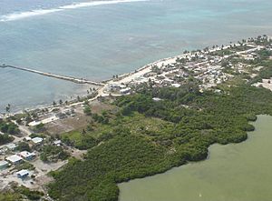
View of Xcalak
|
|
| Country | Mexico |
| Population | |
| • Total | 375 |
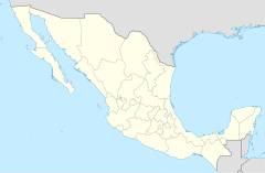
Xcalak (pronounced shka-LAK) is a small village in Mexico. It is located in the state of Quintana Roo, right on the beautiful Caribbean coast. With only about 375 people, Xcalak is known as one of the last "unspoiled" (meaning natural and not heavily developed) places on the Mexican Caribbean.
This village is at the southern end of an area called the Costa Maya. Just offshore, you can find the world's second-largest barrier reef. This amazing reef is a great place for snorkeling and scuba diving. Xcalak is also a starting point for trips to the Chinchorro Bank, which is a special type of reef called an atoll. The area around Xcalak is protected as a Mexican national reef park, called Parque Nacional Arrecifes de Xcalak. It's also a popular spot for fly fishing.
Xcalak is about 60 kilometers (37 miles) south of Mahahual, another coastal town. It is also very close to the border with Belize. While some tourism is growing in the area, it is much less developed than famous places like Cancún and Playa del Carmen further north.
History of Xcalak
The area around Xcalak has been settled for a very long time. The first people to live here were the Maya. You can still find the ruins of an ancient Mayan city nearby, which is where the town of Xcalak gets its name.
In May 1900, the Mexican Navy set up a control post in Xcalak. They also built the first shipyard in the Mexican Caribbean here. This made Xcalak an important place for the region.
During the 1900s, Xcalak grew into a busy town. It was a major center for growing coconuts. Farmers produced huge amounts of coconuts, sometimes as much as 300 tons every month! However, in 1955, a very strong storm called Hurricane Janet hit the city. The hurricane destroyed much of the town and caused many people to move away.
Weather and Climate in Xcalak
Xcalak has a tropical climate, which means it is warm all year round. The weather is usually sunny, but the area can experience strong storms.
In 1955, Hurricane Janet caused a lot of damage to Xcalak. Another strong storm, Hurricane Dean, hit Mahahual, which is only 50 kilometers (31 miles) north of Xcalak, in 2007.
| Climate data for Xcalak | |||||||||||||
|---|---|---|---|---|---|---|---|---|---|---|---|---|---|
| Month | Jan | Feb | Mar | Apr | May | Jun | Jul | Aug | Sep | Oct | Nov | Dec | Year |
| Mean daily maximum °C (°F) | 28.0 (82.4) |
28.0 (82.4) |
29.5 (85.1) |
30.8 (87.4) |
31.7 (89.1) |
31.5 (88.7) |
31.7 (89.1) |
31.8 (89.2) |
31.5 (88.7) |
30.6 (87.1) |
29.1 (84.4) |
27.9 (82.2) |
30.2 (86.4) |
| Mean daily minimum °C (°F) | 21 (70) |
21.3 (70.3) |
22.6 (72.7) |
23.6 (74.5) |
24.5 (76.1) |
24.3 (75.7) |
24.6 (76.3) |
24.5 (76.1) |
24.4 (75.9) |
22.9 (73.2) |
21.9 (71.4) |
20.8 (69.4) |
23.0 (73.4) |
| Average precipitation mm (inches) | 81 (3.2) |
30 (1.2) |
13 (0.5) |
33 (1.3) |
58 (2.3) |
150 (6) |
74 (2.9) |
91 (3.6) |
190 (7.3) |
160 (6.2) |
140 (5.7) |
110 (4.3) |
1,130 (44.6) |
| Source: Weatherbase | |||||||||||||
See also
 In Spanish: Xcalak para niños
 | Toni Morrison |
 | Barack Obama |
 | Martin Luther King Jr. |
 | Ralph Bunche |


