Yale, Michigan facts for kids
Quick facts for kids
Yale, Michigan
|
|
|---|---|

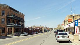
Looking north along S. Main Street
|
|

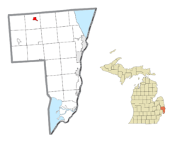
Location within St. Clair County
|
|
| Country | United States |
| State | Michigan |
| County | St. Clair |
| Incorporated | 1889 (village) 1905 (city) |
| Government | |
| • Type | Council–manager |
| Area | |
| • Total | 1.38 sq mi (3.58 km2) |
| • Land | 1.37 sq mi (3.56 km2) |
| • Water | 0.01 sq mi (0.02 km2) |
| Elevation | 794 ft (242 m) |
| Population
(2020)
|
|
| • Total | 1,903 |
| • Density | 1,386.02/sq mi (535.10/km2) |
| Time zone | UTC-5 (Eastern (EST)) |
| • Summer (DST) | UTC-4 (EDT) |
| ZIP code(s) |
48097
|
| Area code(s) | 810 |
| FIPS code | 26-89000 |
| GNIS feature ID | 1625031 |
Yale is a small city located in St. Clair County, in the state of Michigan, United States. In 2020, about 1,903 people lived there.
Yale is sometimes called the "Bologna Capital of the World." This is because of its fun Yale Bologna Festival, which started in 1989. You can even find Yale bologna sold in stores nearby! The city is also home to the Yale Airport, located just south of town.
| Top - 0-9 A B C D E F G H I J K L M N O P Q R S T U V W X Y Z |
History of Yale
The area where Yale now stands first got a post office on May 11, 1865. It was called Brockway Centre back then. The name of the post office changed to Yale on June 24, 1889.
Yale officially became a village in 1889. Later, it became a city in 1905.
Where is Yale?
According to the United States Census Bureau, the city covers a total area of 1.39 square miles (3.60 km2). Most of this area, 1.38 square miles (3.57 km2), is land. Only a tiny part, 0.01 square miles (0.03 km2), is water.
Yale is located in a part of Michigan often called "the Thumb." This area gets its name because it looks like a thumb on a map of Michigan. It's also part of the "Blue Water Area."
People in Yale
| Historical population | |||
|---|---|---|---|
| Census | Pop. | %± | |
| 1890 | 937 | — | |
| 1900 | 1,125 | 20.1% | |
| 1910 | 1,223 | 8.7% | |
| 1920 | 1,223 | 0.0% | |
| 1930 | 1,345 | 10.0% | |
| 1940 | 1,489 | 10.7% | |
| 1950 | 1,641 | 10.2% | |
| 1960 | 1,621 | −1.2% | |
| 1970 | 1,505 | −7.2% | |
| 1980 | 1,814 | 20.5% | |
| 1990 | 1,977 | 9.0% | |
| 2000 | 2,063 | 4.4% | |
| 2010 | 1,955 | −5.2% | |
| 2020 | 1,903 | −2.7% | |
| U.S. Decennial Census | |||
Yale's Population in 2010
In 2010, there were 1,955 people living in Yale. These people lived in 722 households. The city had about 1,416.7 inhabitants per square mile (547.0/km2) people per square mile.
The average age of people in Yale was 38.2 years. About 27% of the residents were under 18 years old. Also, 17.3% of the people were 65 years old or older. There were slightly more females (54.4%) than males (45.6%) in the city.
Yale's Climate
Yale has a type of weather called a humid continental climate. This means the city experiences big changes in temperature throughout the year. Summers are usually warm to hot and can be humid. Winters are cold, and sometimes very cold. This climate is known as "Dfb" on climate maps.
Education in Yale
Yale Public Schools serves the community. The school district is located in the western part of St. Clair County. It's about an hour's drive north of Detroit.
The district covers over 150 square miles. It includes the towns of Avoca, Brockway, Emmett, Fargo, Goodells, Ruby, and Yale. There are five school buildings in the district. They serve about 1,900 students.
- Yale Elementary (Kindergarten to 5th grade)
- John Farrell Emmett Elementary (Kindergarten to 5th grade)
- Avoca Elementary (Kindergarten to 5th grade)
- Yale Junior High School (6th to 8th grade)
- Yale High School (9th to 12th grade)
Yale Public Schools is the largest employer in the area. It has about 105 teachers and over 115 support staff.
See also
 In Spanish: Yale (Míchigan) para niños


