Yanda County facts for kids
Quick facts for kids YandaNew South Wales |
|||||||||||||||
|---|---|---|---|---|---|---|---|---|---|---|---|---|---|---|---|

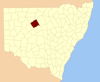
Location in New South Wales
|
|||||||||||||||
|
|||||||||||||||
Yanda County is a special area in New South Wales, Australia. It's one of 141 "counties" that help organize the land. Think of it like a big, old-fashioned map division! The Darling River forms its north-western border, which is a very important river in Australia.
What is Yanda County?
Yanda County is a type of land division called a cadastral division. These divisions were created a long time ago. They help people keep track of land ownership and boundaries. It's like how your town might be divided into different neighborhoods or zones.
The Name Yanda
The name Yanda is believed to come from a local Aboriginal word. These are the first people who lived in Australia for thousands of years. Many places in Australia have names that come from Aboriginal languages. This helps us remember the rich history of the land.
Exploring the Parishes
Inside Yanda County, there are smaller areas called parishes. These are even smaller divisions of land. Each parish has its own name and location. They help local governments manage the land more easily.
Here is a list of the parishes found within Yanda County:
| Parish | LGA | Coordinates |
|---|---|---|
| Bimbera | Bourke Shire | 30°40′02″S 145°41′39″E / 30.66722°S 145.69417°E |
| Bonita | Cobar Shire | 30°46′32″S 145°23′35″E / 30.77556°S 145.39306°E |
| Booroondara | Cobar Shire | 31°04′55″S 145°22′13″E / 31.08194°S 145.37028°E |
| Bright | Cobar Shire | 31°00′35″S 145°02′49″E / 31.00972°S 145.04694°E |
| Brookong | Cobar Shire | 31°02′19″S 145°37′19″E / 31.03861°S 145.62194°E |
| Buckwaroon | Cobar Shire | 31°13′41″S 145°17′21″E / 31.22806°S 145.28917°E |
| Bundaline | Cobar Shire | 31°03′46″S 145°14′50″E / 31.06278°S 145.24722°E |
| Canpadore | Bourke Shire | 30°53′06″S 144°51′15″E / 30.88500°S 144.85417°E |
| Cookadini | Cobar Shire | 31°12′21″S 145°27′41″E / 31.20583°S 145.46139°E |
| Cumbedore | Bourke Shire | 30°46′53″S 144°49′26″E / 30.78139°S 144.82389°E |
| Darling | Bourke Shire | 30°42′22″S 144°55′32″E / 30.70611°S 144.92556°E |
| Derrina | Cobar Shire | 30°48′51″S 145°09′45″E / 30.81417°S 145.16250°E |
| Dootheboy | Cobar Shire | 30°56′56″S 144°57′15″E / 30.94889°S 144.95417°E |
| Dunlop | Bourke Shire | |
| Elutha | Cobar Shire | 31°09′58″S 145°33′28″E / 31.16611°S 145.55778°E |
| Emu | Cobar Shire | 31°00′19″S 145°11′41″E / 31.00528°S 145.19472°E |
| Gellabudda | Bourke Shire | 30°42′17″S 145°17′21″E / 30.70472°S 145.28917°E |
| Ginnewandinia | Bourke Shire | 30°38′20″S 145°29′39″E / 30.63889°S 145.49417°E |
| Gonella | Bourke Shire | 30°47′03″S 145°40′38″E / 30.78417°S 145.67722°E |
| Goonie | Bourke Shire | 30°40′36″S 145°25′28″E / 30.67667°S 145.42444°E |
| Gumhall | Cobar Shire | 30°51′55″S 145°44′44″E / 30.86528°S 145.74556°E |
| Gundabooka | Bourke Shire | 30°48′57″S 145°48′36″E / 30.81583°S 145.81000°E |
| Keirangunyah | Cobar Shire | 30°57′47″S 145°19′14″E / 30.96306°S 145.32056°E |
| Kenindee | Cobar Shire | 31°05′41″S 145°03′42″E / 31.09472°S 145.06167°E |
| Kerie | Bourke Shire | 30°32′47″S 145°14′47″E / 30.54639°S 145.24639°E |
| Lenakka | Cobar Shire | 30°56′56″S 145°36′45″E / 30.94889°S 145.61250°E |
| Maranoa | Cobar Shire | 31°02′18″S 145°28′23″E / 31.03833°S 145.47306°E |
| Merrere | Cobar Shire | 30°57′59″S 145°47′59″E / 30.96639°S 145.79972°E |
| Meutherra | Cobar Shire | 31°03′14″S 145°34′14″E / 31.05389°S 145.57056°E |
| Mitchell | Bourke Shire | 30°35′27″S 145°33′31″E / 30.59083°S 145.55861°E |
| Momble | Cobar Shire | 31°09′08″S 145°06′52″E / 31.15222°S 145.11444°E |
| Mookalimbirria | Cobar Shire | 31°01′44″S 145°50′30″E / 31.02889°S 145.84167°E |
| Mulga | Cobar Shire | 30°51′02″S 145°21′06″E / 30.85056°S 145.35167°E |
| Mulya | Cobar Shire | 30°53′42″S 145°12′46″E / 30.89500°S 145.21278°E |
| Narwarre | Cobar Shire | 30°53′21″S 145°25′07″E / 30.88917°S 145.41861°E |
| Pangunya | Cobar Shire | 31°15′29″S 145°08′16″E / 31.25806°S 145.13778°E |
| Penilui | Bourke Shire | 30°48′24″S 145°36′14″E / 30.80667°S 145.60389°E |
| Pulpulla | Cobar Shire | 31°10′14″S 145°14′16″E / 31.17056°S 145.23778°E |
| Ramsay | Cobar Shire | 30°58′31″S 145°56′54″E / 30.97528°S 145.94833°E |
| Runker | Cobar Shire | 30°55′55″S 145°52′13″E / 30.93194°S 145.87028°E |
| Salisbury | Bourke Shire | 30°47′02″S 145°00′09″E / 30.78389°S 145.00250°E |
| Tatiara | Bourke Shire | 30°28′41″S 145°20′46″E / 30.47806°S 145.34611°E |
| Tigeralba | Bourke Shire | 30°34′13″S 145°23′42″E / 30.57028°S 145.39500°E |
| Tinderra | Cobar Shire | 31°02′08″S 145°56′28″E / 31.03556°S 145.94111°E |
| Toburra | Cobar Shire | 30°53′36″S 145°37′59″E / 30.89333°S 145.63306°E |
| Trethella | Bourke Shire | 30°50′41″S 145°31′40″E / 30.84472°S 145.52778°E |
| Tyngin | Cobar Shire | 30°55′39″S 145°29′11″E / 30.92750°S 145.48639°E |
| Warrego | Bourke Shire | 30°29′40″S 145°31′09″E / 30.49444°S 145.51917°E |
| Winbar | Bourke Shire | |
| Winderra | Bourke Shire | 30°39′04″S 145°18′52″E / 30.65111°S 145.31444°E |
| Wittagoona | Cobar Shire | 31°08′35″S 145°25′04″E / 31.14306°S 145.41778°E |
| Woodhouse | Cobar Shire | 31°06′04″S 145°51′42″E / 31.10111°S 145.86167°E |
| Woolla | Bourke Shire | 30°25′00″S 145°28′51″E / 30.41667°S 145.48083°E |
| Yanda | Bourke Shire | 30°31′17″S 145°36′29″E / 30.52139°S 145.60806°E |
| Yandagulla | Bourke Shire | 30°30′55″S 145°11′12″E / 30.51528°S 145.18667°E |
 | Mary Eliza Mahoney |
 | Susie King Taylor |
 | Ida Gray |
 | Eliza Ann Grier |

