
Yazd province facts for kids
Quick facts for kids
Yazd province
استان یزد
|
|
|---|---|

Clockwise from top left: Meybod as seen from Narin Qal'eh, Tower of Silence outside Yazd, Amir Chakhmaq Mosque and Kharanaq in Ardakan County.
|
|

Location of Yazd province in Iran
|
|
| Country | Iran |
| Region | Region 5 |
| Capital | Yazd |
| Counties | 11 |
| Area | |
| • Total | 76,469 km2 (29,525 sq mi) |
| Population
(2016)
|
|
| • Total | 1,138,533 |
| • Density | 14.88882/km2 (38.56186/sq mi) |
| Time zone | UTC+03:30 (IRST) |
| Main language(s) | Persian |
| HDI (2017) | 0.824 very high · 5th |
| Website | ostanyazd.ir |
Yazd province (Persian: استان یزد, Ostān-e Yazd) is one of the 31 provinces of Iran. It is located in the center of the country. The capital city of the province is Yazd.
In 2014, Yazd province became part of Region 5 in Iran. The total area of the province is about 76,469 square kilometers.
In 2006, about 958,323 people lived in Yazd province. By 2016, the population grew to 1,138,533 people. During this time, Tabas County became a part of South Khorasan province instead of Yazd.
Contents
Exploring Yazd's Geography

Yazd province covers an area of about 129,285 square kilometers. It is like an oasis where two large deserts meet: the Dasht-e Kavir desert and the Dasht-e Lut desert.
The city of Yazd is sometimes called "the bride of the Kavir." This is because of its special location. It sits in a valley between two mountain ranges. One is Shir Kuh, the tallest mountain in the area, standing 4,075 meters high. The other is Kharaneq. The city of Yazd itself is about 1,203 meters above sea level.
Mountains and Landscapes
Yazd province has several mountain ranges. These mountains help shape the landscape of the region.
- South and Southwestern Mountains: This group of mountains is wider than others. It includes the important Shir Kuh mountain.
- Eastern Mountains: These mountains are found in the eastern part of Yazd province. Their highest point is Bon Lokht, which is 3,002 meters tall.
How Yazd Province is Organized

Yazd province is divided into smaller areas called counties. Each county has its own local government. The table below shows how the population of these counties has changed over the years.
| Administrative Divisions | 2006 | 2011 | 2016 |
|---|---|---|---|
| Abarkuh County | 42,610 | 46,662 | 51,552 |
| Ardakan County | 66,900 | 77,758 | 97,960 |
| Ashkezar County | 28,072 | 33,192 | 32,566 |
| Bafq County | 51,507 | 41,876 | 50,845 |
| Behabad County1 | — | 15,331 | 17,221 |
| Khatam County | 31,695 | 35,158 | 36,562 |
| Marvast County2 | — | — | — |
| Mehriz County | 43,363 | 44,126 | 51,733 |
| Meybod County | 70,728 | 82,840 | 99,727 |
| Tabas County3 | 63,047 | 69,658 | — |
| Taft County | 45,357 | 45,145 | 43,893 |
| Yazd County | 515,044 | 582,682 | 656,474 |
| Total | 958,323 | 1,074,428 | 1,138,533 |
| 1Separated from Bafq County 2Separated from Khatam County 3Joined South Khorasan province |
|||
Major Cities in Yazd
Most of the people in Yazd province live in cities. In 2016, about 971,355 people lived in the cities listed below. This was over 85% of the province's total population.
The largest city is Yazd, with 529,673 people. Other important cities include:
- Abarkuh (27,524 people)
- Ardakan (75,271 people)
- Ashkezar (19,123 people)
- Bafq (45,453 people)
- Behabad (9,232 people)
- Herat (13,032 people)
- Marvast (9,379 people)
- Mehriz (34,237 people)
- Meybod (80,712 people)
- Shahediyeh (18,309 people)
- Taft (18,464 people)
- Zarach (11,691 people)
Pictures of Yazd Province
-
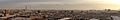
A wide view of Yazd city from the Amir Chakhmaq Complex.
-
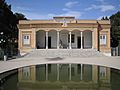
The Zoroastrian temple in Yazd.
-
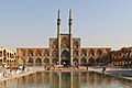
The Amir Chakhmaq Complex in Yazd.


See also
 In Spanish: Provincia de Yazd para niños
