
Ynyshir facts for kids
Quick facts for kids Ynyshir
|
|
|---|---|
 |
|

Ynyshir
|
|
| Population | 3,320 (2011 census) |
| OS grid reference | ST025925 |
| Principal area |
|
| Ceremonial county | |
| Country | Wales |
| Sovereign state | United Kingdom |
| Post town | PORTH |
| Postcode district | CF39 |
| Dialling code | 01443 |
| Police | South Wales |
| Fire | South Wales |
| Ambulance | Welsh |
| EU Parliament | Wales |
| UK Parliament |
|
Ynyshir (pronounced 'Un-is-heer') is a village in South Wales. It is located in the Rhondda Valley, within an area called Rhondda Cynon Taf. The name "Ynyshir" means "long island" in Welsh. This name comes from an old farm in the area.
Ynyshir is found between the smaller village of Wattstown and the larger town of Porth. Today, Ynyshir has a post office, a doctor's surgery, and several shops. It is also home to local football teams like Ynyshir Albions.
Contents
Village History
Before the mid-1800s, Ynyshir was mostly farmland with very few people. This changed when coal mining began.
The Start of Coal Mining
In the 1840s, the first deep coal mine was dug in Ynyshir. This was the very first coal mine in the Rhondda Fach valley. Because of this, Ynyshir became the first village in the valley to grow around a coal mine.
The village first started on the west side of the Rhondda Fach river. Later, it grew on the east side. By the year 1900, most of the village you see today was already built.
Railways and Growth
In 1841, the Taff Vale Railway reached a nearby place called Dinas. This railway made it much easier for coal mine owners to transport their coal. The railway was extended to Ynyshir in 1849. This helped the coal industry and the village grow even more.
Churches and Chapels
Ynyshir was home to many different churches and chapels. These included Ainon Chapel, Bethany Chapel, Moriah Chapel, St Anne's Church, and Saron Chapel. There were also several Welsh and English Methodist chapels.

New School
In 2009, a new modern school called Ynyshir Community Primary School opened. It cost £5.5 million to build. This new school replaced the older Ynyshir Junior School and Ynyshir Infants School.
Coal Mining and Local Inventions
Coal mining was very important to Ynyshir's history.
Early Coal Mines
The first deep mine in Ynyshir was dug in 1845. It was later bought by Francis Crawshay to supply his ironworks. More coal mines opened in the area, including Standard 1 pit in 1875 and Standard 2 pit in 1876. In 1904, the Lady Lewis mine opened. This mine was connected underground to other large collieries, which are now part of the Rhondda Heritage Park.

Lurvills Delight
In 1896, twin brothers from Ynyshir invented a fizzy soft drink called Lurvills Delight. The money they made from this drink helped 150 local mining families move to the United States. Production of the drink stopped in 1910.
Local Government
Ynyshir used to have its own special area for local elections, called an electoral ward. This ward elected one local councillor to the Rhondda Cynon Taf County Borough Council. This council helps make decisions for the local area.
Since 1995, the elected councillor for Ynyshir has been from either the Labour Party or Plaid Cymru. In the May 2017 election, Plaid Cymru won.
Changes were made to the election areas in 2018. Ynyshir was joined with the nearby village of Tylorstown. They now form a new election area called 'Tylorstown and Ynyshir'. These changes started with the 2022 local elections.
Getting Around
Transport has changed a lot in Ynyshir over the years.
The Old Railway Line
From 1849 to 1856, the Taff Vale Railway opened a line that included a station in Ynyshir. People could travel by train until 1964, when passenger services stopped. The railway line was completely closed and removed in 1986.
New Bypass Road
In 2005, the local council built a new road called the A4223 Porth and Lower Rhondda Fach Relief Road. This road is also known as the Porth Bypass. It follows the path of the old railway line through Ynyshir. This new road has greatly reduced the amount of traffic going through the village.
Images for kids
-
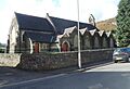
St Anne's Church
-
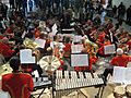
Ynyshir Welfare Band at the Millennium Centre, Cardiff
