
Yosemite Valley Bridges facts for kids
Quick facts for kids |
|
|
Yosemite Valley Bridges
|
|

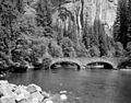
Clark Bridge, with Half Dome in the background
|
|

Location in California

Location in the United States
|
|
| Nearest city | Yosemite Village, California |
|---|---|
| Area | 0 acres (0 ha) |
| Built | 1922 |
| Architect | National Park Service |
| Architectural style | Rustic |
| NRHP reference No. | 77000160 |
| Added to NRHP | November 25, 1977 |
The Yosemite Valley Bridges are a group of eight special bridges found in Yosemite Valley within Yosemite National Park. Most of these bridges cross the beautiful Merced River.
These bridges were built between 1921 and 1933, with five of them finished in 1928. They are made of strong concrete, but they are covered with local stone. This gives them a natural look that fits in with the park's scenery. The bridges are known for looking similar and for following a design style called the National Park Service rustic style. This style uses natural materials and designs that blend into the environment.
The National Park Service chose concrete bridges instead of steel or suspension bridges. This was done to help the bridges look like a natural part of the park's landscape.
Contents
- Exploring Yosemite's Historic Bridges
- Yosemite Creek Bridge: The Oldest Crossing
- Ahwahnee Bridge: A View of Half Dome
- Clark Bridge: Twin Arches for Travelers
- Pohono Bridge: A Simple Crossing
- Sugar Pine Bridge: The Longest Span
- Tenaya Creek Bridge: Crossing a Famous Creek
- Happy Isles Bridge: Clark Bridge's Companion
- Stoneman Bridge: A Later Addition
- Protecting These Historic Crossings
- Images for kids
Exploring Yosemite's Historic Bridges
These bridges are important because they help people get around the park. They also show how park buildings were designed a long time ago. Each bridge has its own story and features.
Yosemite Creek Bridge: The Oldest Crossing
The Yosemite Creek Bridge is the oldest bridge in the group. It was built in 1922. This bridge carries the North Road and crosses Yosemite Creek, which is below the famous Yosemite Falls.
The bridge is about 50 feet (15 meters) long. It has one strong arch made of concrete, covered with granite stones. It is 24 feet (7.3 meters) wide. This bridge replaced an older one that was known as "the little red bridge."
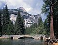
Ahwahnee Bridge: A View of Half Dome
The Ahwahnee Bridge was built in 1928. It crosses the Merced River and has three arches. The longest arch is about 42 feet (13 meters) long. The whole bridge is about 122 feet (37 meters) long.
This bridge is 39 feet (12 meters) wide. It has a road for cars, a sidewalk for people, and a path for horses. The Ahwahnee Bridge carries the Mirror Lake Road. When you drive east on this road, the bridge helps frame a perfect view of Half Dome.
Clark Bridge: Twin Arches for Travelers
The Clark Bridge was also built in 1928. It has one main arch that is about 75.5 feet (23 meters) long. On each side of the main arch, there are two smaller, round arches. These smaller arches are like tunnels, about 7 feet (2.1 meters) wide and 11 feet (3.4 meters) high. They were made for horses and riders to pass through.
This bridge carries the Curry Stables Road. It also has a sidewalk for people and a path for horses.
Pohono Bridge: A Simple Crossing
The Pohono Bridge was built in 1928. It spans about 80 feet (24 meters) across the river. It carries the El Portal Road, which is about 27 feet (8.2 meters) wide. It also has a path for horses, which is about 5 feet (1.5 meters) wide.
Sugar Pine Bridge: The Longest Span
The Sugar Pine Bridge was built in 1928. It is also known as the Kenneyville Bridge No. 2. This bridge is the longest of the eight bridges, spanning about 106 feet (32 meters) across the river.
It carries the Mirror Lake Road. The bridge has a road for cars, a sidewalk for people, and another sidewalk. It was named after a very large sugar pine tree that used to grow near one end of the bridge.
Tenaya Creek Bridge: Crossing a Famous Creek
The Tenaya Creek Bridge was built in 1928. It crosses Tenaya Creek. This bridge has a single arch that is about 56.75 feet (17.3 meters) long. It is located on the Happy Isles-Mirror Lake Road. Like many of the other bridges, it has a road, a path for horses, and a sidewalk.
Happy Isles Bridge: Clark Bridge's Companion
The Happy Isles Bridge was built in 1929 on the Happy Isles Road. It is very similar to the Clark Bridge. It has one main span that is about 75 feet (23 meters) long. It also has two smaller tunnels for horses in its ends, just like the Clark Bridge. The total length of this bridge is about 126 feet (38 meters).
Stoneman Bridge: A Later Addition
The Stoneman Bridge was built in 1933. It looks like the Clark and Happy Isles bridges. Its main span is about 72 feet (22 meters) long. It carries a road that is about 27 feet (8.2 meters) wide and two sidewalks, each about 6 feet (1.8 meters) wide.
The tunnels for horses in this bridge are a bit wider, about 8.5 feet (2.6 meters). This bridge is located near the Camp Curry area. It replaced an old wooden bridge that led to the Stoneman Hotel, which was taken down in the 1920s.
Protecting These Historic Crossings
All these bridges were recognized as a historic district on November 25, 1977. This means they are important parts of history and are protected.
Sometimes, the National Park Service looks at ways to keep the Merced River flowing freely, as it is part of the Wild and Scenic River system. This means they consider different ideas to protect the river. One idea that might be looked at is moving or changing some bridges to help the river flow more naturally. However, any big changes would involve a lot of planning and public discussion.
Images for kids
-
Ahwahnee Bridge
-
Stoneman Bridge


