Zeba, Michigan facts for kids
Quick facts for kids
Zeba, Michigan
Ziibiins
|
|
|---|---|

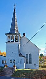
Zeba Indian United Methodist Church
|
|

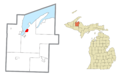
Location within Baraga County
|
|
| Country | |
| State | |
| County | |
| Township | L'Anse |
| Area | |
| • Total | 3.62 sq mi (9.38 km2) |
| • Land | 3.61 sq mi (9.35 km2) |
| • Water | 0.01 sq mi (0.03 km2) |
| Elevation | 860 ft (260 m) |
| Population
(2020)
|
|
| • Total | 397 |
| • Density | 109.97/sq mi (42.47/km2) |
| Time zone | UTC-5 (Eastern (EST)) |
| • Summer (DST) | UTC-4 (EDT) |
| ZIP code(s) |
49946 (L'Anse)
|
| Area code(s) | 906 |
| FIPS code | 26-89240 |
| GNIS feature ID | 2628828 |
Zeba (which is called Ziibiins in the Ojibwe language) is a small community in Baraga County, Michigan, in the United States. It's known as an "unincorporated community," meaning it doesn't have its own local government like a city or town. It's also a "census-designated place" (CDP), which is a special area the U.S. Census Bureau defines for gathering population data. In 2020, Zeba had a population of 397 people. The community is located near the southern end of Keweenaw Bay, just north of the village of L'Anse.
Contents
History of Zeba
The name Zeba means "river" in the Ojibwe language. This name was chosen because a small stream flows southeast of the community. Zeba once had a post office that operated at different times between 1910 and 1933.
Early Settlements and Missions
Zeba's history is very similar to that of nearby L'Anse. The same missionaries and traders were active in both places. The American Fur Trading Company had a trading post in Zeba. This made Zeba an important place for shipping goods like furs, animal hides, and sandstone.
Zeba was first settled in 1831. This was when Father Frederic Baraga, a Catholic priest, arrived. He set up the area's first mission along the southern shore of Lake Superior's Keweenaw Bay. Some of the early settlers included Peter Marksman Sr., Peter Hall, William Bass, and Benjamin George.
Historic Buildings and Culture
Overlooking the lake is the Zeba Indian United Methodist Church. This church was built in 1888 and is known for its Gothic style. It was originally called the Kewawenon Mission. Today, it is listed on the National Register of Historic Places, which means it's recognized as an important historical site.
About two miles inland, there's a cemetery on Indian Cemetery Road in an area called the Pinery. This cemetery dates back to the 1840s. It's special because it uses "spirit houses" instead of traditional gravestones.
Today, Zeba is part of the Keweenaw Bay Indian Community (KBIC). This community is made up of the Lake Superior Band of Chippewa Indians. Nearby, you can find the Pinery Lakes Trail, which is an 8-mile long path popular for cross-country skiing.
Climate
|
||||||||||||||||||||||||||||||||||||||||||||||||||||||||||||||||||||||||||||||||||||||||||||||||
Zeba experiences a climate with cold winters and mild summers, typical of the Upper Peninsula of Michigan.
Demographics
| Historical population | |||
|---|---|---|---|
| Census | Pop. | %± | |
| 2020 | 397 | — | |
| U.S. Decennial Census | |||
According to the 2010 census, Zeba had 480 people living in 183 households. Out of these, 132 were families. The community's population was made up of different groups. About 45.2% of the people were White, and 46.9% were Native American. About 7.7% of the population identified as being from two or more races. A small percentage, 1.3%, were Hispanic or Latino.
See also
 In Spanish: Zeba (Míchigan) para niños
 | Kyle Baker |
 | Joseph Yoakum |
 | Laura Wheeler Waring |
 | Henry Ossawa Tanner |


