Zelaya Department facts for kids
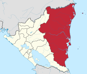
Zelaya was once a large area, like a state or province, in the country of Nicaragua. It was located along the Mosquito Coast, which is a part of Nicaragua that borders the Caribbean Sea. This area was named after José Santos Zelaya, who was a former president of Nicaragua. He helped Nicaragua gain control of this region in 1894. The main city, or capital, of Zelaya was Bluefields.
History of Zelaya
Zelaya was named after José Santos Zelaya, who served as the President of Nicaragua. In 1894, President Zelaya led an effort to bring the Mosquito Coast region under Nicaragua's full control. Before this, the Mosquito Coast was a special area with its own local leaders and was protected by the British. After 1894, it became a part of Nicaragua and was later organized as the Zelaya department.
How Zelaya Changed
In 1987, the large department of Zelaya was divided into two smaller, self-governing areas. These new areas are called "autonomous regions" because they have more power to make their own decisions about local matters.
The two new regions are:
- North Caribbean Coast Autonomous Region (often called NCCAR)
- South Caribbean Coast Autonomous Region (often called SCCAR)
These changes were made to give the local people in the Caribbean coastal areas more say in how their communities are run.
Where Was Zelaya Located?
The Zelaya department was located on the eastern side of Nicaragua. It stretched along the Mosquito Coast, which is a long coastline next to the Caribbean Sea. This area is known for its unique culture and natural environment.
See also
 In Spanish: Departamento de Zelaya para niños
 | Leon Lynch |
 | Milton P. Webster |
 | Ferdinand Smith |


