Zell, Missouri facts for kids
Quick facts for kids
Zell, Missouri
|
|
|---|---|

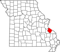
Location of Ste. Genevieve County, Missouri
|
|
| Country | United States |
| State | Missouri |
| County | Sainte Genevieve |
| Township | Ste. Genevieve |
| Elevation | 623 ft (190 m) |
| Time zone | UTC-6 (Central (CST)) |
| • Summer (DST) | UTC-5 (CDT) |
| ZIP code |
63670
|
| Area code(s) | 573 |
| FIPS code | 29-81466 |
Zell is a small community in Missouri, United States. It's not a city with its own government, but a part of Ste. Genevieve County. You can find Zell about six miles west of the town of Sainte Genevieve.
Contents
What's in a Name?
Zell got its name from a town in Germany. The original settlers of Zell came from a place called Zell am Harmersbach. This German town is in the Baden-Württemberg region. It is located about 10 miles southeast of Offenburg.
A Look at Zell's History
Zell was first settled in 1798. A large piece of land was given to Pierre Charles Dehault Delassus Deluziere. He called this land the Prairie Gautier Tract.
After Delassus passed away, the land was sold to his son. Later, it was sold again to his nephew, Felix de St. Vrain.
German Settlers Arrive
In 1837, German Catholic families moved to this area. At that time, the place was known as Nouvelle Alsace. This French name means "New Alsace".
In 1840, the community was renamed Zell. A Catholic church, St. Joseph, was built there between 1845 and 1847.
Where is Zell Located?
Zell is found in Ste. Genevieve Township. It is just northeast of Interstate 55. You can reach Zell by following Missouri Route A.
Zell's Climate
The weather in Zell has hot and humid summers. The winters are generally cold.
Understanding the Climate Type
According to a system called Köppen Climate Classification, Zell has a humid subtropical climate. This means it has warm temperatures for most of the year. It also gets a good amount of rain. On climate maps, this type of weather is shown as "Cfa".
| Climate data for Zell, MO | |||||||||||||
|---|---|---|---|---|---|---|---|---|---|---|---|---|---|
| Month | Jan | Feb | Mar | Apr | May | Jun | Jul | Aug | Sep | Oct | Nov | Dec | Year |
| Mean daily maximum °F (°C) | 40.0 (4.4) |
45.0 (7.2) |
56.0 (13.3) |
68.0 (20.0) |
77.5 (25.3) |
86.0 (30.0) |
90.0 (32.2) |
89.0 (31.7) |
81.0 (27.2) |
70.0 (21.1) |
56.0 (13.3) |
44.0 (6.7) |
66.9 (19.4) |
| Daily mean °F (°C) | 30.0 (−1.1) |
35.0 (1.7) |
45.0 (7.2) |
56.0 (13.3) |
65.0 (18.3) |
74.0 (23.3) |
78.5 (25.8) |
76.5 (24.7) |
68.5 (20.3) |
57.0 (13.9) |
45.0 (7.2) |
35.0 (1.7) |
55.5 (13.0) |
| Mean daily minimum °F (°C) | 20.0 (−6.7) |
24.0 (−4.4) |
33.0 (0.6) |
43.0 (6.1) |
54.0 (12.2) |
63.0 (17.2) |
67.0 (19.4) |
64.0 (17.8) |
56.0 (13.3) |
44.0 (6.7) |
34.0 (1.1) |
25.0 (−3.9) |
43.9 (6.6) |
| Average precipitation inches (mm) | 2.3 (58) |
2.3 (58) |
3.6 (91) |
4.0 (100) |
4.8 (120) |
3.8 (97) |
3.9 (99) |
3.4 (86) |
3.2 (81) |
3.1 (79) |
3.7 (94) |
3.5 (89) |
41.6 (1,052) |
| Source: NOAA | |||||||||||||
 | Aaron Henry |
 | T. R. M. Howard |
 | Jesse Jackson |

