Zinberg Glacier facts for kids
Quick facts for kids Zinberg Glacier |
|
|---|---|

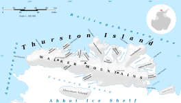
Map of Thurston Island.
|
|
| Location | Thurston Island Ellsworth Land |
| Coordinates | 72°21′00″S 96°4′00″W / 72.35000°S 96.06667°W |
| Thickness | unknown |
| Status | unknown |
The Zinberg Glacier (72°21′S 96°4′W / 72.350°S 96.067°W) is a large river of ice. It is located on the eastern side of Thurston Island in Antarctica. This glacier flows towards the east-northeast. It empties into a body of water called Morgan Inlet. The glacier is found between the Tierney Peninsula and a piece of land known as Ryan Point.
What is Zinberg Glacier?
A glacier is a huge mass of ice that moves very slowly over land. The Zinberg Glacier is one of these ice rivers. It is found on Thurston Island, which is part of a larger area called Ellsworth Land in Antarctica. The glacier's ice slowly slides towards the sea. It eventually reaches Morgan Inlet, where it might break off into icebergs.
How it got its name
The Zinberg Glacier was named by the Advisory Committee on Antarctic Names (US-ACAN). This committee is responsible for naming places in Antarctica. They named the glacier after Corporal E. Zinberg. He was a photographer in the United States Army.
Corporal Zinberg was part of a special mission called U.S. Navy Operation Highjump. This operation happened between 1946 and 1947. During this time, the team took many aerial photographs. These photos helped map Thurston Island and the nearby coastal areas. The glacier was named to honor his work on this important mapping project.
See also
 In Spanish: Glaciar Zinberg para niños


