
Zutendaal facts for kids
Quick facts for kids
Zutendaal
|
|||
|---|---|---|---|
 |
|||
|
|||

Zutendaal
Location in Belgium
|
|||
| Country | Belgium | ||
| Community | Flemish Community | ||
| Region | Flemish Region | ||
| Province | Limburg | ||
| Arrondissement | Hasselt | ||
| Area | |||
| • Total | 32.07 km2 (12.38 sq mi) | ||
| Population
(2018-01-01)Lua error in Module:Wd at line 1575: attempt to index field 'wikibase' (a nil value).
|
|||
| • Total | Lua error in Module:Wd at line 1,575: attempt to index field 'wikibase' (a nil value). | ||
| Postal codes |
3690
|
||
| Area codes | 089 | ||
| Website | www.zutendaal.be | ||


Zutendaal (which sounds like "zoo-ten-daal") is a small town in Belgium. It is located in the Limburg province. On January 1, 2017, about 7,269 people lived there. The town covers an area of 32.07 square kilometers. This means about 227 people live in each square kilometer.
Besides the main town of Zutendaal, there are other smaller areas. These include Gewaai, Papendaal, Besmer, Broek, Stalken, Roelen, Daal, and Wiemesmeer.
Contents
What Does the Name Zutendaal Mean?
The first time Zutendaal was written about was in 1292. It was called Suerbroeck back then. This name meant "acidic swampy land." It described the wet, sour ground around the village.
Later, in 1345, the name changed to Zuetendael. This new name means "Sweet Valley." It showed that there were many fresh water sources nearby.
A Quick Look at Zutendaal's History
Some of the oldest parts of Zutendaal are Papendaal, Broek, Stalken, and Roelen. These areas grew near natural springs. Other parts like Wiemesmeer, Gewaai, and Besmer were built later. Besmer used to be part of another town called Lanaken. It became part of Zutendaal in the 1800s.
Early Buildings and Changes
People believe the first church in Zutendaal was built around the 600s. It was started by monks from the Abbey of Munsterbilzen. In 1304, a powerful count gave the church to the Abbey of Averbode. You can still see parts of the old village center today. It is located around the town square, called Vijverplein.
Times of Trouble and Battles
In the 1500s and 1600s, Zutendaal faced many problems. Groups of traveling soldiers caused trouble. In 1598, the church was even burned down. People had to build defenses to stay safe from these soldiers.
Later, in 1790, a battle happened on Hesselsberg hill. This fight was between local revolutionaries and soldiers from another region. The soldiers were supporting the Prince-Bishop of Liège.
Modern Developments in Zutendaal
In the late 1800s and early 1900s, the heathland around Zutendaal was planted with trees. These trees were grown to provide wood for mining. In 1938, a factory that made explosives was built in the area.
During World War II, in 1944, American forces built the Zutendaal Air Base. A big battle called Operation Bodenplatte happened there on January 1, 1945. After the war, in 1953, the air base became a reserve base for NATO.
What Zutendaal is Like Today
Zutendaal is known for having many forests. It is one of the most wooded towns in Flanders. Because of this, tourism is an important way for people to earn money.
Fun Things to Do in Zutendaal
The town is famous for its barefoot path at the Lieteberg. This is a special path where you walk without shoes. It is also one of the main entrances to the Hoge Kempen National Park. This large park almost completely surrounds Zutendaal.
Besides tourism, some companies in Zutendaal dig for sand and gravel. Zutendaal is also part of a group of towns along the Albert Canal. This group works together to help the local economy.
How Zutendaal's Population Has Grown
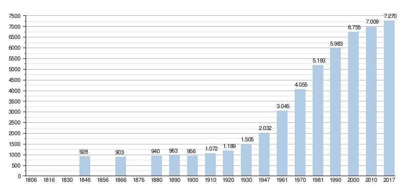
- Sources: NIS. Note: 1806 to 1981 = census data; 1990 and later = population on January 1st.
Images for kids
-
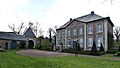
The old parsonage (priest's house) of Zutendaal.
-
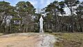
A statue of Maria on the Hesselsberg hill.
-
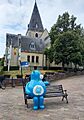
A statue called Warm William, with the Zutendaal church in the background.
-
The Lieteberg, an entrance to the Hoge Kempen National Park.
-
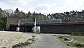
The building that used to be the chaplaincy (a priest's residence).
-
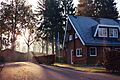
One of the many vacation parks in Zutendaal.
-
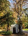
One of the many small chapels you can find in Zutendaal.
-
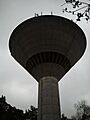
The water tower in Zutendaal.
-
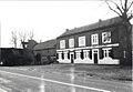
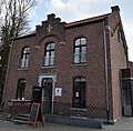
The building that was once the post office.
-
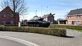
A tank monument near the Zutendaal Air Base.

_Hesselsberg_5-04-2019_13-27-59.jpg)


.jpg)


.jpg)
See also
 In Spanish: Zutendaal para niños
