Älvdalen Municipality facts for kids
Quick facts for kids
Älvdalen Municipality
Älvdalens kommun
Älvdaelien tjïelte |
||
|---|---|---|
 |
||
|
||
 |
||
| Country | Sweden | |
| County | Dalarna County | |
| Seat | Älvdalen | |
| Area | ||
| • Total | 7,189.45 km2 (2,775.86 sq mi) | |
| • Land | 6,917.28 km2 (2,670.78 sq mi) | |
| • Water | 272.17 km2 (105.09 sq mi) | |
| Area as of January 1, 2010. | ||
| Population
(June 30, 2012)
|
||
| • Total | 7,248 | |
| • Density | 1.00814/km2 (2.61108/sq mi) | |
| Time zone | UTC+1 (CET) | |
| • Summer (DST) | UTC+2 (CEST) | |
| ISO 3166 code | SE | |
| Province | Dalarna and Härjedalen | |
| Municipal code | 2039 | |
| Website | www.alvdalen.se | |
| Density is calculated using land area only. | ||
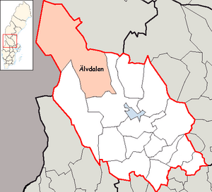
Älvdalen Municipality is a special area in central Sweden. It is located in Dalarna County. The main town, or "seat," of the municipality is Älvdalen.
The name Älvdalen means "River Valley." This name comes from the area around the town of Älvdalen. This town sits along the Österdal River.
This municipality has a long history. In 1645, two areas called Särna and Idre became part of Sweden. Before that, they belonged to Norway. Later, in 1971, the areas of Särna, Idre, and Älvdalen joined together. This created the municipality we know today. The coat of arms for Älvdalen shows streams and hills. This represents the beautiful landscape of the area.
Contents
Exploring Älvdalen's Geography
Älvdalen Municipality is quite diverse. It can be thought of as having three main parts. These are the mountainous north, the forest in the middle, and the valley in the south.
The Northern Mountains
The northern part of Älvdalen is in the Scandinavian mountain range. This area has cultural ties to the Sámi people. They are the native people of this region.
Idre is a town in the north. It has about 800 people and is a popular place for skiing.
This part of the municipality has some very tall mountains. These include Storvätteshågna, which is 1,204 meters high. Another tall mountain is Städjan, at 1,131 meters. The Töfsingdalen National Park is also found here. It is in the very northern part of the municipality. This northern area is the furthest north point of Svealand. Svealand is one of the three main regions of Sweden.
The Central Forests
The middle part of Älvdalen is covered in forests. The national park Fulufjället is also located here. This area shares a border with Norway. Because of this, its history includes many stories and signs of past border conflicts. The lower part of the municipality's coat of arms shows a crossbow. This symbolizes its history with border disputes. The point in Scandinavia that is furthest from any sea is found in this central area.
The town of Särna is in this forest part. It is along the Österdal River and has about 930 people. Like Idre, Särna's main business is tourism. Särna used to be part of Norway. But in 1644, Swedish farmers took control of it. It officially became part of Sweden later, in 1751.
The Southern Valley
The southern part of Älvdalen is home to about 5,000 people. Many of them speak or understand Elfdalian. This is a special dialect or language. It is very different from standard Swedish.
This area is known for its interesting culture. The town of Älvdalen is here. There are also several other important villages. These include Evertsberg, Blyberg, Klitten, Brunnsberg, Västermyckeläng, and Åsen.
Towns and Villages
Here are some of the towns and villages in Älvdalen Municipality:
- Älvdalen
- Ärnäs
- Åsen
- Brunnsberg
- Evertsberg
- Idre
- Klitten
- Rot
- Särna
- Väsa
- Västermyckeläng
See also
 In Spanish: Municipio de Älvdalen para niños
 | John T. Biggers |
 | Thomas Blackshear |
 | Mark Bradford |
 | Beverly Buchanan |


