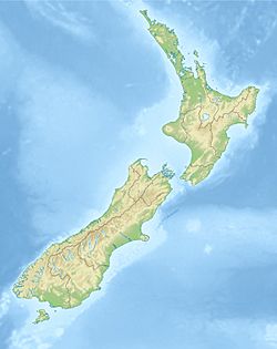
2014 Eketahuna earthquake facts for kids
| UTC time | 2014-01-20 02:52:44 |
|---|---|
| ISC event | 604055704 |
| USGS-ANSS | ComCat |
| Local date | 20 January 2014 |
| Local time | 3:52 pm NZDT (UTC+13) |
| Magnitude | 6.2 ML |
| Depth | 34 kilometres (21 mi) |
| Epicenter | 40°37′S 175°52′E / 40.62°S 175.86°E |
| Type | Oblique-normal |
| Areas affected | New Zealand |
| Peak acceleration | 0.26 g |
| Aftershocks | 1112 |
| Casualties | 3 injured |
The 2014 Eketahuna earthquake was a strong earthquake that hit New Zealand on January 20, 2014. It happened at 3:52 pm and was centered about 15 kilometers (9 miles) east of Eketahuna. This town is located on the southeast side of New Zealand's North Island.
When the earthquake first happened, experts thought it was a magnitude 6.6 on the Richter scale. This scale measures the strength of an earthquake. Later, they changed the measurement to a magnitude of 6.2. People felt the shaking very strongly. It was rated as "severe" on the Mercalli intensity scale, which describes how much people felt the shaking and the damage it caused. After the main earthquake, there were 1,112 smaller earthquakes called aftershocks. These aftershocks ranged from magnitude 2.0 to 4.9.
Why Earthquakes Happen in New Zealand
New Zealand is a place where two huge pieces of the Earth's crust, called tectonic plates, meet. These are the Indo-Australian Plate and the Pacific Plate. These plates are always moving, but very slowly. When they push against each other, or slide past each other, stress builds up. When this stress is released, it causes an earthquake.
In New Zealand, the plates meet in different ways. In the South Island, they mostly slide past each other along a big fault line called the Alpine Fault. A fault is like a crack in the Earth's crust. In the North Island, the Pacific Plate is actually sliding underneath the Indo-Australian Plate. This process is called subduction. The 2014 Eketahuna earthquake happened because of this movement deep within the Pacific Plate as it was sliding down.
Damage Caused by the Earthquake
The earthquake was felt across a large part of New Zealand. People felt it from Auckland in the north all the way down to Dunedin in the south. More than 9,000 people sent reports to GeoNet, which is a group that monitors natural hazards like earthquakes.
News reports said that walls and chimneys were damaged in the lower North Island. Some roads had to be closed because of the shaking. The Earthquake Commission (EQC) helps people whose homes are damaged by natural disasters. They received over 5,000 claims for damage from this earthquake. Many of these claims came from Palmerston North.
Other towns also reported damage, including Eketahuna, Wellington, Masterton, Carterton, Kapiti Coast, Pahiatua, Levin, and Otaki. In Masterton, three old buildings from the 1920s had to be emptied because cracks appeared in them. One of these buildings was so badly damaged that it had to be torn down. Two people were hurt from falling during the earthquake.
In Palmerston North, a place called Hokowhitu Lagoon was also affected. It is thought that the earthquake damaged the bottom of the lagoon, causing water to leak out.


