A Lama facts for kids
Quick facts for kids
A Lama
|
||
|---|---|---|
|
||

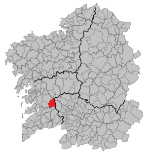
Location of A Lama within Galicia
|
||
| Country | ||
| Autonomous community | ||
| Province | Pontevedra | |
| Comarca | Pontevedra | |
| Population
(2018)
|
||
| • Total | 2,430 | |
| Time zone | UTC+1 (CET) | |
| • Summer (DST) | UTC+2 (CET) | |
A Lama is a small town in Spain. It is located in the province of Pontevedra, which is part of the region called Galicia. A Lama is also part of an area known as the Pontevedra comarca.
Contents
What Does A Lama Mean?
The name "A Lama" has an interesting history. Long ago, this area was known by different names, like Cal de Vergaza and Pedreira.
The Meaning of Lama
The word lama comes from the Latin word LAMA. In the Galician language, which is spoken in this part of Spain, lama means a place made of mud. So, the town's name tells us something about its natural landscape.
Where is A Lama Located?
A Lama is a municipality, which is like a local government area, in the province of Pontevedra. It is mostly a rural area, meaning it has lots of countryside, farms, and natural spaces.
Exploring A Lama's Geography
This municipality is found in the northeast part of the Pontevedra province. It covers an area of about 111.76 square kilometers. If you want to visit, it's about 31 kilometers from the city of Pontevedra and 50 kilometers from Vigo.
Neighboring Towns and Roads
A Lama shares its borders with several other towns. To the northwest is Cotobade, and to the west is Ponte Caldelas. Fornelos de Montes is to the south, and Forcarei is to the northeast. To the east, you'll find Beariz, which is in a different province called Ourense.
The main roads that help people get around A Lama include:
- The road from Pontevedra to A Cañiza, which passes through the areas of Verducido and Gaxate.
- The road from Cotobade, which goes through Antas and connects to Beariz.
See also
 In Spanish: La Lama para niños
 | Precious Adams |
 | Lauren Anderson |
 | Janet Collins |


