
Abagadasset River facts for kids
Quick facts for kids Abagadasset River |
|
|---|---|


Location of Abagadasset River mouth
|
|
| Other name(s) | Tributary to Kennebec River |
| Country | United States |
| State | Maine |
| County | Kennebec Sagadahoc |
| Physical characteristics | |
| Main source | Cobbosseecontee Stream divide about 0.1 miles south of Libby Hill, Maine 280 ft (85 m) 44°09′31″N 069°50′31″W / 44.15861°N 69.84194°W |
| River mouth | Kennebec River about 1.5 miles west of Chops Crossroads, Maine at Merrymeeting Bay 0 ft (0 m) 44°00′35″N 069°51′06″W / 44.00972°N 69.85167°W |
| Length | 13.52 mi (21.76 km) |
| Basin features | |
| Progression | generally south |
| River system | Kennebec River |
| Basin size | 20.86 square miles (54.0 km2) |
| Tributaries |
|
| Bridges | I-295, Beedle Road, Alexander Reed Road, Langdon Road, ME 197, Carding Machine Road, ME 24, Browns Point Road |
The Abagadasset River is a river in Maine, United States. It flows for about 16 miles (26 kilometers). This river is special because it's a tributary to the Kennebec River. A tributary is a smaller stream or river that flows into a larger one.
The Abagadasset River starts near Libby Hill in Maine. It then flows generally south through towns like Richmond and Bowdoinham. Its journey ends when it flows into Merrymeeting Bay. This bay is part of the estuary of the Kennebec River. An estuary is where a river meets the sea, and fresh water mixes with salt water.
Contents
River Facts: What to Know
The Abagadasset River is an important part of the local water system. It helps carry water from the land into the larger Kennebec River.
Where Does It Flow?
The river travels through two counties in Maine:
How Long is the Abagadasset River?
The river stretches for about 13.5 miles (21.7 kilometers). This makes it a medium-sized river in the area.
What is a River Basin?
The Abagadasset River has a basin size of about 20.86 square miles (54 square kilometers). A river basin is all the land area where water drains into that river. Think of it like a giant funnel!
Bridges Over the River
Several bridges cross the Abagadasset River, helping people travel. These include:
- I-295 (a major highway)
- Beedle Road
- Alexander Reed Road
- Langdon Road
- ME 197 (a state route)
- Carding Machine Road
- ME 24 (another state route)
- Browns Point Road
Images for kids
-
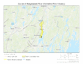
Course of Abagadasset River
-
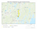
Watershed of Abagadasset River
.gif)
.gif)
See Also
