Acadia Valley facts for kids
Quick facts for kids
Acadia Valley
|
|
|---|---|
 |
|
| Country | Canada |
| Province | Alberta |
| Planning region | Red Deer |
| Municipal district | M.D. of Acadia No. 34 |
| Government | |
| • Type | Unincorporated |
| Area
(2021)
|
|
| • Land | 0.46 km2 (0.18 sq mi) |
| Elevation | 716 m (2,349 ft) |
| Population
(2021)
|
|
| • Total | 143 |
| • Density | 308.1/km2 (798/sq mi) |
| Time zone | UTC−7 (MST) |
| • Summer (DST) | UTC−6 (MDT) |
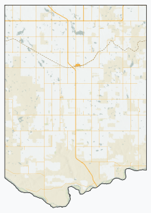
Acadia Valley is a small community called a hamlet in southeastern Alberta, Canada. It's located within the Municipal District of Acadia No. 34, which is like a local government area. The main office for this district is actually right here in Acadia Valley!
Acadia Valley is found along Alberta Highway 41, also known as Buffalo Trail. This highway connects towns like Oyen and Medicine Hat. The hamlet is about 14.5 kilometers (9 miles) west of the border between Alberta and Saskatchewan. It sits at an elevation of 716 meters (2,349 feet) above sea level.
This area is part of what's called Census Division No. 4. The community got its name in 1910 from settlers who came from Nova Scotia, a province on Canada's east coast.
How Many People Live Here?
In 2021, a count of people called the 2021 Census of Population showed that 143 people lived in Acadia Valley. These people lived in 71 homes out of 86 total homes in the area.
This number was a little less than in 2016, when 149 people lived here. Acadia Valley covers a small land area of about 0.46 square kilometers (0.18 square miles). This means there were about 308 people per square kilometer in 2021.
Fun Things to Do
- Prairie Elevator Museum - This is a museum about old grain elevators, which were important buildings for farming.
- Acadia Municipal Recreation Dam - You can go trout fishing here!


