Acme, Washington facts for kids
Quick facts for kids
Acme, Washington
|
|
|---|---|
| Etymology: Greek word meaning "culmination" or "top or highest point | |

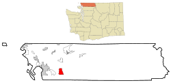
Location of Acme, Washington
|
|
| Country | United States |
| State | Washington |
| County | Whatcom |
| Area | |
| • Total | 9.8 sq mi (25.4 km2) |
| • Land | 9.8 sq mi (25.4 km2) |
| • Water | 0.0 sq mi (0.0 km2) |
| Elevation | 305 ft (93 m) |
| Population
(2020)
|
|
| • Total | 229 |
| • Density | 23.37/sq mi (9.02/km2) |
| Time zone | UTC-8 (Pacific (PST)) |
| • Summer (DST) | UTC-7 (PDT) |
| ZIP code |
98220
|
| Area code | 360 |
| FIPS code | 53-00275 |
| GNIS feature ID | 1515719 |
Acme is a small, quiet community in Whatcom County, Washington, United States. It's a "census-designated place" (CDP), which means it's an area the government tracks for population, but it's not an official town or city with its own local government.
In Acme, you'll find a general store, a post office, a gas station, a diner, an elementary school, and two churches. The population of the entire Acme CDP was 229 people in 2020. This was a slight decrease from 246 people in 2010.
Acme is located in the beautiful South Fork Valley. This valley sits between the northern Cascade Mountains and Lake Whatcom. People know Acme as a scenic spot with many places to camp near Lake Whatcom. You can even find the Lake Whatcom Railroad here.
Contents
History of Acme's Name
There are two main stories about how Acme got its name. Both stories agree that the name came about around 1887.
Naming Story One
The first story says that a man named Samuel Parks named the community. He chose the name "Acme" around 1887. He got the idea from a hymnal, which is a book of church songs, that he owned.
Naming Story Two
The second story also points to the year 1887. It claims that a local resident, George Parls, named the town. He supposedly named it after a new "Acme" hymn book that a local church had just received.
Meaning of Acme
No matter which story is true, the word "acme" comes from an old Greek word. It means "culmination" or "the top or highest point."
Geography of Acme
Acme is located at specific coordinates: 48°42′55″N 122°12′36″W / 48.71528°N 122.21000°W.
The area known as the Acme CDP covers about 9.8 square miles (25.4 square kilometers). All of this area is land, with no large bodies of water within its official boundaries.
Population Information
In the year 2000, there were 263 people living in the Acme CDP. This means there were about 26.8 people per square mile.
The average household in Acme had about 3.20 people living in it. The average family had about 3.52 people.
Age Groups in Acme
The population in 2000 was spread out across different age groups:
- About 37.6% of the people were under 18 years old.
- About 8.4% were between 18 and 24 years old.
- About 28.5% were between 25 and 44 years old.
- About 19.8% were between 45 and 64 years old.
- About 5.7% were 65 years old or older.
The median age, which is the middle age of all the people, was 30 years old.
Notable People from Acme
Some well-known individuals have connections to Acme:
- Ann Anderson – She was a former member of the Washington State Senate. This is a group of elected officials who help make laws for the state of Washington.
- Paul R. Brass – He is a famous scholar. A scholar is someone who studies a lot and knows a lot about a specific topic. Paul R. Brass is known for his work on ethnic politics, political violence, and Indian politics.
See also
 In Spanish: Acme (Washington) para niños

