Adjungbilly facts for kids
Quick facts for kids AdjungbillyNew South Wales |
|||||||||
|---|---|---|---|---|---|---|---|---|---|

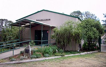
Adjungbilly Community Hall
|
|||||||||
| Postcode(s) | 2727 | ||||||||
| Elevation | 514 m (1,686 ft) | ||||||||
| Location |
|
||||||||
| LGA(s) | Cootamundra-Gundagai Regional Council | ||||||||
| County | Buccleuch | ||||||||
| State electorate(s) | Cootamundra | ||||||||
| Federal Division(s) | Riverina | ||||||||
|
|||||||||
Adjungbilly is a small rural community. It is located in the central east part of the Riverina region. This area is also on the north-western edge of the Snowy Mountains in New South Wales, Australia. It's about 29 kilometers southeast of Gobarralong. It's also 35 kilometers northeast of Tumut.
Contents
History of Adjungbilly
The first post office in this area opened in 1896. It was first called Tomooroma Post Office. In 1899, its name changed to Adjungbilly. This post office served the community until it closed in 1974.
What's in a Name?
The name Adjungbilly comes from the local Wiradjuri language. The original name was Nadjongbilla. In Wiradjuri, "nadjong" means water. "Billa" means creek. So, Adjungbilly means "creek with permanent water." This name describes the area's natural water supply.
Community Life in Adjungbilly
Adjungbilly has a community hall. This hall is a place for local events. There is also a small, isolated primary school. It is called Bongongo Public School. This school is likely named after the nearby Bongongo Station.
Climate in Adjungbilly
Adjungbilly is located between the western plains of New South Wales and the Great Dividing Range. Because of this, its temperatures change a lot between seasons. It gets most of its rain in winter. It is also common for snow to fall here.
| Climate data for Red Hill State Forest (1938–1970); 640 m AMSL; 35.17° S, 148.37° E | |||||||||||||
|---|---|---|---|---|---|---|---|---|---|---|---|---|---|
| Month | Jan | Feb | Mar | Apr | May | Jun | Jul | Aug | Sep | Oct | Nov | Dec | Year |
| Mean daily maximum °C (°F) | 28.7 (83.7) |
27.8 (82.0) |
25.1 (77.2) |
19.5 (67.1) |
14.5 (58.1) |
11.1 (52.0) |
10.0 (50.0) |
11.7 (53.1) |
15.3 (59.5) |
18.6 (65.5) |
21.9 (71.4) |
26.3 (79.3) |
19.2 (66.6) |
| Mean daily minimum °C (°F) | 12.5 (54.5) |
12.8 (55.0) |
10.5 (50.9) |
6.7 (44.1) |
3.7 (38.7) |
1.9 (35.4) |
0.8 (33.4) |
1.5 (34.7) |
3.3 (37.9) |
5.9 (42.6) |
8.0 (46.4) |
10.8 (51.4) |
6.5 (43.7) |
| Average precipitation mm (inches) | 73.3 (2.89) |
56.1 (2.21) |
76.1 (3.00) |
78.6 (3.09) |
108.3 (4.26) |
96.5 (3.80) |
117.0 (4.61) |
118.9 (4.68) |
91.5 (3.60) |
105.3 (4.15) |
85.1 (3.35) |
70.0 (2.76) |
1,076.7 (42.39) |
| Average precipitation days (≥ 0.2 mm) | 6.5 | 5.9 | 6.3 | 8.1 | 11.8 | 12.9 | 14.5 | 15.2 | 11.5 | 12.1 | 9.2 | 7.5 | 121.5 |
| Source: Australian Bureau of Meteorology; Red Hill State Forest | |||||||||||||
 | Kyle Baker |
 | Joseph Yoakum |
 | Laura Wheeler Waring |
 | Henry Ossawa Tanner |


