
Aizkorri facts for kids
Quick facts for kids Aizkorri |
|
|---|---|

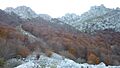
Aizkorri crests.
|
|
| Highest point | |
| Elevation | 1,551 m (5,089 ft) |
| Naming | |
| Language of name | Basque |
| Pronunciation | Basque: [aisˈkori] |
| Geography | |
| Location | Gipuzkoa, Spain |
| Parent range | Basque mountains |
| Climbing | |
| Easiest route | From Arantzazu |
Aizkorri or Aitzgorri is a famous mountain range in the Basque Country of Spain. Its name means 'bare stone' or 'red stone' in the Basque language. The highest point in this range is Aitxuri peak, which stands at 1,551 meters (about 5,089 feet) above sea level. Aitxuri means 'white stone'.
The Aizkorri range is made up of several peaks lined up in a row. These include Artzanburu, Andreaitz, Arbelaitz (1,513 m), Iraule (1,511 m), Aitxuri, Aketegi (1,549 m), and the Aizkorri peak itself (1,528 m). Even though Aizkorri peak is not the tallest, it is the most well-known and popular. This mountain range is a very noticeable part of the Basque Mountains.


The Aizkorri mountains are bordered by two passes: Biozkornia and San Adrian. To the west, the range connects with the Aloña mountains. To the east, it joins the Altzania mountains, where the highest peak is Aratz. A major railway line that goes from Madrid to Irun cuts through the northern slopes of the Aizkorri range. There used to be two train stops, Otzaurte and Zegama Apeadero, but they are hardly used anymore.
Contents
How to Reach Aizkorri
There are several ways to get to the Aizkorri peaks. Some paths are more challenging than others.
Starting from Zegama
The old train stop, Zegama Apeadero, is now known as a starting point for a tough trail. This path goes straight up to a central pass near Andreaitz. The trail begins as a muddy track heading west. It then becomes a narrow path at a major crossroads called Intzuzaeta. From there, the trail goes into a thick beech forest, where it can be hard to spot. As you get higher, the path winds up. You leave the forest behind and enter an area with unique rocky landscapes and grazing fields.
Starting from Arantzazu
The most common way to climb Aizkorri is from the southwest, starting at the Sanctuary of Arantzazu in Oñati. A clear path leads through a dense beech forest and ends at the Urbia meadows. From these meadows, you can climb up to the main peaks like Aizkorri, Aketegi, and Aitxuri. The route is well-marked, so it's easy to follow.
Starting from San Adrian Tunnel
Another way to access the mountains is from the east, near the San Adrian tunnel. This tunnel is part of an old Medieval road. After walking about 50 meters from the southern exit of the tunnel, you'll find a trail on your right. This trail goes steeply uphill through the forest for about 30 minutes. It's even called Kalbario Bidea, which means 'Calvary Trail', because it's so steep and has loose stones.
Once you reach an opening, you get a beautiful view to the north. The trail then follows along the edge of some limestone cliffs. In another 30 minutes, you can reach the Aizkorri summit. Near the summit, there is a simple refuge hut built in 1934 for shepherds and hikers. There is also a small chapel called the Santo Cristo hermitage.
Events and Nature
The Aizkorri mountains are a popular spot for outdoor activities and are also protected for their natural beauty.
Zegama-Aizkorri Marathon
Every spring, a famous cross-country running race called the Zegama-Aizkorri Marathon takes place here. Runners follow a loop around the Aizkorri mountain range, sometimes including the nearby Aratz mountain. It's a challenging and exciting event.
Aizkorri-Aratz Natural Park
To protect the beautiful nature of the area, the entire Aizkorri and Aratz region was made into the Aizkorri-Aratz Natural Park in 2006. This means the plants, animals, and landscapes are preserved for everyone to enjoy.

Images for kids
-
Aizkorri crests.
See also
 In Spanish: Aitzgorri para niños
