Alamosa East, Colorado facts for kids
Quick facts for kids
Alamosa East, Colorado
|
|
|---|---|

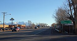
Looking east along U.S. Route 160 (Santa Fe Avenue) in Alamosa East.
|
|

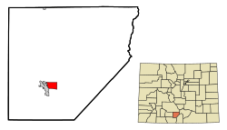
Location of the Alamosa East CDP in Alamosa County, Colorado
|
|
| Country | |
| State | |
| County | Alamosa County |
| Government | |
| • Type | unincorporated community |
| Area | |
| • Total | 3.249 sq mi (8.414 km2) |
| • Land | 3.249 sq mi (8.414 km2) |
| • Water | 0 sq mi (0.000 km2) |
| Elevation | 7,540 ft (2,300 m) |
| Population
(2020)
|
|
| • Total | 1,453 |
| • Density | 447.26/sq mi (172.69/km2) |
| Time zone | UTC-7 (MST) |
| • Summer (DST) | UTC-6 (MDT) |
| ZIP Code |
Alamosa 81101
|
| Area code(s) | 719 |
| GNIS feature | 2407709 |
Alamosa East is a small community in Alamosa County, Colorado, United States. It's called an "unincorporated community" because it doesn't have its own city government. Instead, it's managed by the county. It's also a "census-designated place" (CDP), which means the United States Census Bureau counts its population separately. In 2020, about 1,453 people lived there. The local post office in Alamosa handles mail for Alamosa East.
Where is Alamosa East?
Alamosa East covers an area of about 8.4 square kilometers (or 2,079 acres). All of this area is land, with no lakes or rivers inside the community itself.
How Many People Live Here?
The United States Census Bureau first officially counted the population of Alamosa East in 1970. A "census" is like a big count of all the people living in a place. It helps us understand how communities are growing or changing.
| Alamosa East CDP, Colorado | ||
|---|---|---|
| Year | Pop. | ±% |
| 1970 | 1,040 | — |
| 1980 | 1,175 | +13.0% |
| 1990 | 1,389 | +18.2% |
| 2000 | 1,528 | +10.0% |
| 2010 | 1,458 | −4.6% |
| 2020 | 1,453 | −0.3% |
| Source: United States Census Bureau | ||
See also
 In Spanish: Alamosa East (Colorado) para niños
 | Precious Adams |
 | Lauren Anderson |
 | Janet Collins |


