Alberche facts for kids
Quick facts for kids Alberche |
|
|---|---|

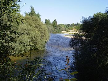
The Alberche near Aldea del Fresno
|
|
 |
|
| Country | Spain |
| Physical characteristics | |
| Main source | Fuente Alberche, Ávila Province 1,800 m (5,900 ft) |
| River mouth | Tagus 373 m (1,224 ft) |
| Length | 100 km (62 mi) |
| Basin features | |
| Progression | Tagus→ Atlantic Ocean |
| Basin size | 4,108 km2 (1,586 sq mi) |
| Tagus Basin | |
The Alberche is a river located in central Spain. It flows through three different areas: Ávila, Madrid, and Toledo. This river is about 100 kilometers (62 miles) long.
The Alberche River starts high up in the mountains, at about 1,800 meters (5,900 feet) above sea level. Its source is called Fuente Alberche, found in the San Martín de la Vega del Alberche area of Ávila Province. The river naturally separates two mountain ranges: the Sierra de Gredos and the Sierra de Guadarrama. These ranges are part of a larger mountain system called the Sistema Central.
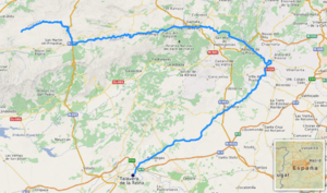
The river generally flows from the northwest to the southeast. However, about halfway along its path, it makes a sharp turn. After this turn, it flows from the northeast towards the southwest. The Alberche River eventually joins the Tagus River, which is one of the longest rivers in the Iberian Peninsula. This meeting point is a few kilometers east of Talavera de la Reina.
Along its journey, the Alberche River has several important dams. These dams help to control the water flow and create reservoirs. Some of the dams on the Alberche include Burguillo, Charco del Cura, San Juan, Picadas, and Cazalegas. One popular spot on the river is Alberche Beach. This sandy area is a favorite place for people from Madrid to visit and relax, especially during holidays.
River Branches
The Alberche River has several smaller rivers that flow into it. These smaller rivers are called tributaries. They add more water to the main river as it travels.
See also
 In Spanish: Alberche para niños
 | Delilah Pierce |
 | Gordon Parks |
 | Augusta Savage |
 | Charles Ethan Porter |

