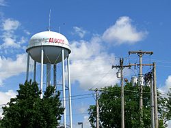
Algood, Tennessee facts for kids
Quick facts for kids
Algood, Tennessee
|
|
|---|---|
 |
|

Location of Algood in Putnam County, Tennessee.
|
|
| Country | United States |
| State | Tennessee |
| County | Putnam |
| Incorporated | 1911 |
| Named for | Joel Algood |
| Area | |
| • Total | 4.09 sq mi (10.59 km2) |
| • Land | 4.09 sq mi (10.59 km2) |
| • Water | 0.00 sq mi (0.00 km2) |
| Elevation | 1,112 ft (339 m) |
| Population
(2020)
|
|
| • Total | 3,963 |
| • Density | 968.95/sq mi (374.15/km2) |
| Time zone | UTC-6 (Central (CST)) |
| • Summer (DST) | UTC-5 (CDT) |
| ZIP code |
38506
|
| Area code(s) | 931 |
| FIPS code | 47-00640 |
| GNIS feature ID | 1304798 |
Algood is a city located in Putnam County, Tennessee, United States. It is a part of the larger Cookeville area. In 2020, about 3,963 people lived there.
Contents
History of Algood
How Algood Got Started
Even though Algood became a city later, a small community existed nearby in the early 1800s. This community was called White Plains. It was a large farm and an important stop on the Walton Road. This road connected the cities of Nashville and Knoxville.
In the 1880s, a railroad company built a train station where Algood is today. The land for the station was bought from an early settler named Joel Algood. He was a "circuit rider," which means he traveled around to preach. The train stop was named after him. For a while, the area was even called "Algood's Old Fields."
Becoming a City
In 1899, the Algood Methodist Church was built on land given by Joel Algood's children. Algood first became an official city in 1901. However, the city decided to give up its official status two years later. The town then became an official city again in 1911.
Geography of Algood
Where is Algood Located?
Algood is located at the bottom of Algood Mountain. This mountain is about 1,456 feet (444 meters) high. It is one of many low, wide hills in the area. These hills look like "stair steps" leading up from the Highland Rim to the Cumberland Plateau.
The city is mainly found along what used to be State Route 42. This road is also known as Main Street. It is just east of where State Route 42 used to meet State Route 111.
Land Area
The United States Census Bureau says that Algood covers about 4.0 square miles (10.59 square kilometers). All of this area is land, with no large bodies of water.
Population in Algood
How Many People Live Here?
The number of people living in Algood has changed over the years. Here is how the population has grown:
| Historical population | |||
|---|---|---|---|
| Census | Pop. | %± | |
| 1920 | 651 | — | |
| 1930 | 643 | −1.2% | |
| 1940 | 609 | −5.3% | |
| 1950 | 729 | 19.7% | |
| 1960 | 886 | 21.5% | |
| 1970 | 1,808 | 104.1% | |
| 1980 | 2,406 | 33.1% | |
| 1990 | 2,399 | −0.3% | |
| 2000 | 2,942 | 22.6% | |
| 2010 | 3,495 | 18.8% | |
| 2020 | 3,963 | 13.4% | |
| Sources: | |||
In 2020, the city had 3,963 people living in 1,883 households. There were 1,138 families living in Algood at that time.
See also
 In Spanish: Algood para niños
 | Roy Wilkins |
 | John Lewis |
 | Linda Carol Brown |

