Alins facts for kids
Quick facts for kids
Alins
|
||
|---|---|---|
|
Municipality
|
||
 |
||
|
||

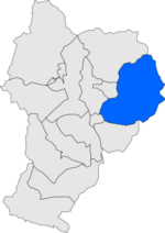
Location in Pallars Sobirà county
|
||
| Sovereign state | ||
| Community | ||
| Region | Alt Pirineu | |
| County | Pallars Sobirà | |
| Province | Lleida | |
| Area | ||
| • Total | 183.2 km2 (70.7 sq mi) | |
| Elevation | 1,048 m (3,438 ft) | |
| Population
(2018)
|
||
| • Total | 290 | |
| • Density | 1.583/km2 (4.10/sq mi) | |
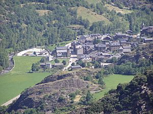
Alins is a small town and municipality located in the beautiful Pallars Sobirà county in Catalonia, Spain. It's nestled in the Pyrenees mountains, very close to the borders of Occitania in France and La Massana in Andorra. In 2022, about 285 people lived in Alins.
Discover Alins
Alins covers the valleys of the Noguera de Vallferrera and Tor rivers. These rivers are in the northern part of the Pallars Sobirà county.
Tallest Peak in Catalonia
The famous Pica d'Estats mountain is part of the Montcalm Massif and is located here. It stands at 3,142 meters (about 10,308 feet) high. This makes it the tallest point in all of Catalonia! The mountain is right on the border between Alins and Ariège, France.
Getting Around Alins
A local road connects the municipality of Alins to the main L-504 road. This makes it easier to travel to and from the area.
People and Villages
The municipality of Alins is made up of seven different villages. Some of these villages are special because they are "delocalised municipal entities." This means they have their own small local councils. These councils have some limited powers to manage local matters in their village.
Here are the villages and their populations as of 2005:
- Ainet de Besan (35)
- Alins (58)
- Araós (29)
- Àreu (84)
- Besan (5)
- Norís (12)
- Tor (25), which is connected to Andorra by a forest track
See also
 In Spanish: Alins para niños
 | Claudette Colvin |
 | Myrlie Evers-Williams |
 | Alberta Odell Jones |


