Allakaket, Alaska facts for kids
Quick facts for kids
Allakaket
Aalaa Kkaakk’et
|
|
|---|---|

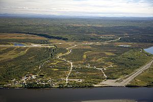
Aerial view of Allakaket
|
|
| Country | United States |
| State | Alaska |
| Census Area | Yukon-Koyukuk |
| Incorporated | 1975 |
| Area | |
| • Total | 17.03 sq mi (44.12 km2) |
| • Land | 14.72 sq mi (38.12 km2) |
| • Water | 2.32 sq mi (6.00 km2) |
| Elevation | 400 ft (122 m) |
| Population
(2020)
|
|
| • Total | 177 |
| • Density | 12.03/sq mi (4.64/km2) |
| Time zone | UTC-9 (Alaska (AKST)) |
| • Summer (DST) | UTC-8 (AKDT) |
| ZIP code |
99720
|
| Area code | 907 |
| FIPS code | 02-01860 |
| GNIS feature ID | 1398129 |
Allakaket (/æləˈkækɪt/ AL-ə-KAK-it) is a small city in Alaska, a state in the United States. It's located in the Yukon-Koyukuk Census Area. In 2020, about 177 people lived there. The city's name in the Koyukon is Aalaa Kkaakk’et.
Contents
History and Culture
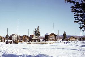
Different Native groups, like the Koyukon Athabascans and Eskimos, have lived in this area for a long time. The Koyukon people used to move around with the seasons. They followed wild animals and fish for food. After 1851, different groups started living together in settlements. The old site of Alatna was a place where Athabascans and Eskimos traded goods.
The first mission, St. John's-in-the-Wilderness Episcopal Mission, was built in 1906. A post office opened in 1925. In 1938, the community's name changed to Allakaket. The small Eskimo community across the river took the name Alatna. The first public school was built in 1957.
In 1964, a big flood covered most of the community. This happened because ice jammed the river. In 1975, Allakaket became an official city. It included both the Allakaket and Alatna settlements. A health clinic and an airport were built in 1978. A new school and roads were finished in 1979.
Another major flood happened in September 1994. It destroyed almost all the buildings, homes, and food supplies for winter. People rebuilt their homes near the old city site. Some new homes and facilities are now outside the city limits. New Allakaket and Alatna are also outside the city.
The Allakaket Village is a federally recognized tribe in the community. Most of the people living here are Alaska Native. Allakaket is mainly an Athabascan community. Kobuk Eskimos live across the river in Alatna. There are two separate village councils. Traditional gatherings, dances, and foot races bring visitors from nearby villages. People get most of their food by hunting, fishing, and gathering.
Geography
Allakaket is located at 66°33′48″N 152°38′50″W / 66.56333°N 152.64722°W. It is in the Fairbanks Recording District.
The city is on the south bank of the Koyukuk River. It is southwest of where the Koyukuk River meets the Alatna River. Allakaket is about 190 miles (306 km) northwest of Fairbanks. It is also about 57 miles (92 km) upriver from Hughes. The village of Alatna is right across the river.
The city covers a total area of 4.3 square miles (11.1 km2). About 3.6 square miles (9.3 km2) of this is land. The remaining 0.7 square miles (1.8 km2) is water.
Climate
Allakaket has a subarctic climate. This means it has very cold, snowy winters and mild summers. The average high temperature in July is about 70 °F (21 °C). In January, temperatures often drop to 0 °F (-18 °C) or lower. It can get even colder, with long periods below -40 °F (-40 °C).
The highest temperature ever recorded was 94 °F (34 °C). The lowest temperature ever recorded was -75 °F (-59 °C). The area gets about 12.41 inches (315 mm) of rain each year. It also gets about 61.3 inches (1.56 m) of snow annually. The Koyukuk River is usually free of ice from June to October.
| Climate data for Allakaket (1961–1990 normals, extremes 1907–1982) | |||||||||||||
|---|---|---|---|---|---|---|---|---|---|---|---|---|---|
| Month | Jan | Feb | Mar | Apr | May | Jun | Jul | Aug | Sep | Oct | Nov | Dec | Year |
| Record high °F (°C) | 49 (9) |
45 (7) |
45 (7) |
65 (18) |
83 (28) |
92 (33) |
94 (34) |
88 (31) |
82 (28) |
55 (13) |
43 (6) |
39 (4) |
94 (34) |
| Mean maximum °F (°C) | 22.7 (−5.2) |
23.2 (−4.9) |
34.6 (1.4) |
48.3 (9.1) |
69.7 (20.9) |
79.8 (26.6) |
83.8 (28.8) |
79.1 (26.2) |
63.6 (17.6) |
43.8 (6.6) |
29.9 (−1.2) |
25.8 (−3.4) |
85.2 (29.6) |
| Mean daily maximum °F (°C) | −10.9 (−23.8) |
−3.9 (−19.9) |
13.5 (−10.3) |
33.0 (0.6) |
53.0 (11.7) |
67.2 (19.6) |
70.3 (21.3) |
65.0 (18.3) |
50.2 (10.1) |
27.3 (−2.6) |
4.5 (−15.3) |
−6.4 (−21.3) |
30.3 (−0.9) |
| Daily mean °F (°C) | −21.2 (−29.6) |
−18.3 (−27.9) |
−4.0 (−20.0) |
18.1 (−7.7) |
41.8 (5.4) |
55.1 (12.8) |
58.0 (14.4) |
52.0 (11.1) |
38.4 (3.6) |
18.0 (−7.8) |
−6.6 (−21.4) |
−17.1 (−27.3) |
17.9 (−7.8) |
| Mean daily minimum °F (°C) | −31.0 (−35.0) |
−30.6 (−34.8) |
−20.2 (−29.0) |
3.5 (−15.8) |
28.8 (−1.8) |
42.0 (5.6) |
44.6 (7.0) |
38.3 (3.5) |
26.7 (−2.9) |
8.1 (−13.3) |
−16.7 (−27.1) |
−29.2 (−34.0) |
5.4 (−14.8) |
| Mean minimum °F (°C) | −58.2 (−50.1) |
−59.5 (−50.8) |
−48.4 (−44.7) |
−24.0 (−31.1) |
12.9 (−10.6) |
29.8 (−1.2) |
32.7 (0.4) |
24.8 (−4.0) |
12.5 (−10.8) |
−17.7 (−27.6) |
−44.8 (−42.7) |
−56.1 (−48.9) |
−61.6 (−52.0) |
| Record low °F (°C) | −75 (−59) |
−70 (−57) |
−68 (−56) |
−45 (−43) |
−17 (−27) |
17 (−8) |
21 (−6) |
17 (−8) |
−4 (−20) |
−41 (−41) |
−61 (−52) |
−69 (−56) |
−75 (−59) |
| Average precipitation inches (mm) | 0.92 (23) |
0.60 (15) |
0.40 (10) |
0.44 (11) |
0.55 (14) |
1.14 (29) |
1.77 (45) |
2.02 (51) |
1.24 (31) |
1.40 (36) |
1.19 (30) |
0.84 (21) |
12.50 (318) |
| Average snowfall inches (cm) | 11.6 (29) |
5.3 (13) |
7.4 (19) |
5.5 (14) |
0.3 (0.76) |
0.0 (0.0) |
0.0 (0.0) |
0.0 (0.0) |
1.6 (4.1) |
10.4 (26) |
7.5 (19) |
3.7 (9.4) |
53.3 (135) |
| Average precipitation days | 3.8 | 4.5 | 3.9 | 6.0 | 5.8 | 8.9 | 10.3 | 12.3 | 9.1 | 8.8 | 5.6 | 6.4 | 85.4 |
| Average snowy days (≥ 0.01 inch) | 4.4 | 2.7 | 2.4 | 4.3 | 0.3 | 0.0 | 0.0 | 0.0 | 0.4 | 5.4 | 3.5 | 1.8 | 25.2 |
| Source 1: WRCC | |||||||||||||
| Source 2: XMACIS (snowfall) | |||||||||||||
Population of Allakaket
| Historical population | |||
|---|---|---|---|
| Census | Pop. | %± | |
| 1920 | 85 | — | |
| 1940 | 105 | — | |
| 1950 | 79 | −24.8% | |
| 1960 | 115 | 45.6% | |
| 1980 | 163 | — | |
| 1990 | 170 | 4.3% | |
| 2000 | 97 | −42.9% | |
| 2010 | 105 | 8.2% | |
| 2020 | 177 | 68.6% | |
| U.S. Decennial Census | |||
Allakaket first appeared in the 1920 U.S. Census. In 1930, it was counted with the nearby village of Alatna. Allakaket officially became a city in 1975. This included the village of Alatna across the river.
After the 1994 flood, many people from Alatna moved to higher ground. This new area was just outside the city limits. So, in 2000, Alatna became its own separate census-designated place.
In 2000, there were 97 people living in Allakaket. Most of the people (about 96%) were Alaska Native. There were 41 households in the city. About 27% of these households had children under 18.
Public Services
Many public buildings were badly damaged in the 1994 Koyukuk River flood. Since then, important parts have been replaced. These include a new laundry facility (washeteria) and a water treatment plant. There is also a large water storage tank and a sewage system.
The sewage system connects to the washeteria and the school. Most homes do not have indoor plumbing. Residents carry treated water to their homes. They use special buckets or outdoor toilets for waste. Work is still being done to improve the water and sewage systems. A new landfill is also being built.
Alaska Power Company provides electricity to the city. There is one school in the community. It serves about 52 students. The Yukon–Koyukuk School District runs the Allakaket School.
There is also a health clinic called Allakaket Health Clinic. It provides basic health care. Allakaket is considered an isolated village. Emergency services are available by river and air. A health aide provides emergency care.
Economy and Transportation
Most jobs in Allakaket are part-time or seasonal. The main year-round jobs are at the school, the City government, the Tribe, and the village store. In the summer, some people work in construction. Others help with emergency firefighting for the BLM.
A few people earn money by trapping animals. Some also sell traditional Native handmade items. However, the local economy mainly focuses on subsistence. This means people get most of their food from the land. They hunt salmon, whitefish, moose, and bear. They also gather small game and berries. Caribou are hunted when they are available.
Allakaket does not have roads connecting it to other towns. But in winter, there are trails to Hughes, Bettles, and Tanana. River transportation is important in summer. However, large commercial boats cannot reach the city because the water is too shallow.
The state-owned Allakaket Airport has a gravel runway. It is open all year. Several airlines offer passenger flights to Allakaket. These include Arctic Circle Air Service, Servant Air, Warbelow's Air Ventures, and Wright Air Service.
Notable people
- Jay Ramras (born 1964), businessman, politician
- Steven "Tig" Strassburg (born 1986), "First Alaskans" - National Geographic
See also
 In Spanish: Allakaket (Alaska) para niños


