Allegheny Mountain (West Virginia – Virginia) facts for kids
Quick facts for kids Allegheny Mountain |
|
|---|---|

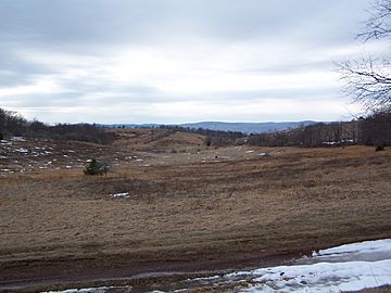
Camp Allegheny battlefield at Top of Allegheny.
|
|
| Highest point | |
| Peak | Paddy Knob (Pocahontas County, WV and Highland County, VA) |
| Elevation | 4,478 ft (1,365 m) |
| Geography | |
| Location | Tamarack Ridge in Highland County, VA |
| Country | United States |
| Range coordinates | 38°28′47″N 79°41′37″W / 38.47972°N 79.69361°W |
| Parent range | Allegheny Mountains |
Allegheny Mountain (sometimes spelled Alleghany Mountain in Virginia) is a big mountain ridge. It is found in the southern part of the Allegheny Mountains. These mountains are a larger part of the Appalachian Mountains.
This mountain acts like a natural border. It helps form the Eastern Continental Divide. This is like an imaginary line where rainwater flows either east to the Atlantic Ocean or west to the Gulf of Mexico. Allegheny Mountain also marks part of the border between Virginia and West Virginia. Many parts of Allegheny Mountain are taller than 4,000 feet (about 1,200 meters).
Exploring Allegheny Mountain's Tallest Spots
This mountain has many high points, often called peaks or knobs. They are listed here from southwest to northeast:
- Hickory Knob - 3,309 feet (1,009 meters)
- Smith Knob
- Chestnut Knob
- High Top (Lookout Tower)
- Chestnut Levels
- Mad Tom
- Mad Sheep - 4,225 feet (1,288 meters)
- Paddy Knob - 4,477 feet (1,365 meters)
- Bald Knob
- Watering Pond Knob
- Bear Mountain
- Top of Allegheny (This is where the Camp Allegheny battlefield is located)
- Tamarack Ridge
- Grassy Knob
Natural Pathways Through the Mountain
Mountains often have lower areas or passes called gaps. These gaps make it easier to travel across the mountain. Here are some of the main gaps in Allegheny Mountain:
- Rucker Gap
- Ryder Gap
 | May Edward Chinn |
 | Rebecca Cole |
 | Alexa Canady |
 | Dorothy Lavinia Brown |


