Altable facts for kids
Quick facts for kids
Altable
|
|||
|---|---|---|---|
|
Municipality and town
|
|||

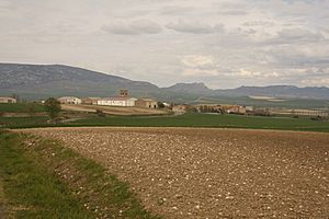
View of Altable, 2010
|
|||
|
|||
| Country | Spain | ||
| Autonomous community | |||
| Province | |||
| Comarca | Comarca del Ebro | ||
| Area | |||
| • Total | 8.22 km2 (3.17 sq mi) | ||
| Elevation | 710 m (2,330 ft) | ||
| Population
(2018)
|
|||
| • Total | 53 | ||
| • Density | 6.45/km2 (16.70/sq mi) | ||
| Time zone | UTC+1 (CET) | ||
| • Summer (DST) | UTC+2 (CEST) | ||
| Postal code |
09219
|
||
| Website | http://www.altable.es/ | ||
Altable is a small municipality and town in Spain. It is located in the province of Burgos, which is part of the Castile and León region. In 2018, about 53 people lived there.
Where is Altable Located?
Altable is found in the Ebro Valley region of Spain. It is about 66 kilometers (around 41 miles) away from the city of Burgos.
Roads and Travel
The town is near the N-232 national road. This road helps connect Altable to other places. There is also a local road that goes towards a nearby town called Valluércanes.
Mountains and Rivers
To the north of Altable, you'll find the Obarenes Mountains. These mountains create a beautiful natural border. As you move away from the mountains, the land becomes flatter. Several small streams flow through this flat area, which is where the town is built.
The land rises again to the south, but it is mostly flat there too. The highest point in the area is about 950 meters (3,117 feet) high in the north. The lowest point is around 670 meters (2,198 feet) in the east, near the Ea River. The town of Altable itself sits at an elevation of 712 meters (2,336 feet) above sea level.
See also
 In Spanish: Altable para niños
 | Sharif Bey |
 | Hale Woodruff |
 | Richmond Barthé |
 | Purvis Young |


