Altamont, Missouri facts for kids
Quick facts for kids
Altamont, Missouri
|
|
|---|---|
|
Village
|
|
| Village of Altamont | |

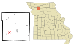
Location of Altamont, Missouri
|
|
| Country | United States |
| State | Missouri |
| County | Daviess |
| Founded | 1890 |
| Incorporated | 1896 |
| Area | |
| • Total | 0.26 sq mi (0.67 km2) |
| • Land | 0.26 sq mi (0.66 km2) |
| • Water | 0.00 sq mi (0.01 km2) |
| Elevation | 1,017 ft (310 m) |
| Population
(2020)
|
|
| • Total | 171 |
| • Density | 667.97/sq mi (257.79/km2) |
| Time zone | UTC-6 (Central (CST)) |
| • Summer (DST) | UTC-5 (CDT) |
| ZIP code |
64620
|
| Area code(s) | 660 |
| FIPS code | 29-00910 |
| GNIS feature ID | 2397947 |
Altamont is a small village located in the southwest part of Daviess County, Missouri, in the United States. In 2020, about 171 people lived there.
History of Altamont
Altamont was first planned and settled around 1890. The village got its name because it is located on high ground. A post office has been open in Altamont since 1890, helping people send and receive mail for over a century.
Where is Altamont?
Altamont is found along Missouri Route 6. It is about three miles northeast of a town called Winston. Another town, Gallatin, is about six miles to the northeast.
The United States Census Bureau says that Altamont covers a total area of about 0.26 square miles (0.67 square kilometers). All of this area is land.
People of Altamont
| Historical population | |||
|---|---|---|---|
| Census | Pop. | %± | |
| 1900 | 288 | — | |
| 1910 | 270 | −6.2% | |
| 1920 | 349 | 29.3% | |
| 1930 | 272 | −22.1% | |
| 1940 | 274 | 0.7% | |
| 1950 | 178 | −35.0% | |
| 1960 | 190 | 6.7% | |
| 1970 | 225 | 18.4% | |
| 1980 | 192 | −14.7% | |
| 1990 | 188 | −2.1% | |
| 2000 | 218 | 16.0% | |
| 2010 | 204 | −6.4% | |
| 2020 | 171 | −16.2% | |
| U.S. Decennial Census | |||
In 2010, there were 204 people living in Altamont. These people made up 79 households and 56 families. The village had about 680 people per square mile.
Most of the people in Altamont were White (99.51%). A small number (0.49%) were Native American.
About 38% of the households had children under 18 living with them. Many households (46.8%) were married couples living together. The average household had about 2.58 people.
The ages of the people in Altamont varied. About 29.9% were under 18 years old. About 13.3% were 65 years or older. The average age in the village was 37.5 years.
Education in Altamont
Students in Altamont attend public schools run by the Gallatin R-V School District. This district is located in Gallatin.
Younger students, from pre-kindergarten to 6th grade, go to Covel D. Searcy Elementary School. Older students, from 7th to 12th grade, attend Gallatin High School.
Most adults in Altamont (94.3%) have finished high school or gone even further in their education. About 6.6% of adults have earned a bachelor's degree or a higher degree.
See also
 In Spanish: Altamont (Misuri) para niños

