Amanu facts for kids

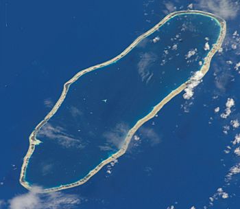
NASA picture of Amanu Atoll
|
|
| Geography | |
|---|---|
| Location | Pacific Ocean |
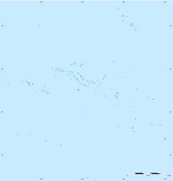
| Coordinates | 17°48′22″S 140°45′39″W / 17.80611°S 140.76083°W |
| Archipelago | Tuamotus |
| Area | 240 km2 (93 sq mi) (lagoon) 15.55 km2 (6 sq mi) (above water) |
| Length | 32 km (19.9 mi) |
| Width | 10 km (6 mi) |
| Administration | |
|
France
|
|
| Overseas collectivity | French Polynesia |
| Administrative subdivision | Îles Tuamotu-Gambier |
| Commune | Hao |
| Largest settlement | Ikitake |
| Demographics | |
| Population | 192 (2012) |
| Pop. density | 20 /km2 (50 /sq mi) |
Amanu, also called Timanu or Karere, is a special kind of island called an atoll. It is part of the Tuamotu archipelago in the Pacific Ocean. Amanu is unique because it lies at a right angle to its neighbor, Hao Atoll. This unusual direction is rare for atolls in the Tuamotu group.
This atoll is located about 900 kilometers (560 miles) east of Tahiti. It is also just 15 kilometers (9 miles) north of Hao. Amanu is about 32 kilometers (20 miles) long from northeast to southwest. It is also about 10 kilometers (6 miles) wide.
Most of Amanu is covered by its central lagoon, which is a large, shallow body of water. The lagoon covers 240 square kilometers (93 square miles). Only a small part of the land, about 15.55 square kilometers (6 square miles), is above the water. There are two safe channels that boats can use to enter the lagoon.
Amanu has a small population of about 195 people. The main village on the atoll is called Ikitake.
Contents
Amanu's Past: Who Found It?
The first European explorer to officially record visiting Amanu Atoll was a Portuguese navigator named Pedro Fernández de Quirós. He was sailing for Spain when he arrived on February 12, 1606. He was exploring the Pacific Ocean, looking for a large southern land.
Mysterious Cannons
However, something interesting happened in 1929. Several old Spanish cannons from the 1500s were found on Amanu. This suggests that an even earlier Spanish trip might have visited the Tuamotu islands. Some historians, like Robert Adrian Langdon, believe these cannons came from a ship called the San Lesmes. This ship was part of the Loaísa expedition that sailed the Pacific in 1526.
Later Explorers
Another Spanish explorer, Domingo de Boenechea, visited Amanu in 1774. He mapped the islands and named them Las Ánimas, which means "The Souls" in Spanish.
Later, in 1820, a Russian explorer named Fabian Gottlieb von Bellingshausen came to Amanu. He was on his ships, Vostok and Mirni. Bellingshausen gave this atoll the name "Moller".
How Amanu is Governed
Amanu is part of French Polynesia, which is an overseas territory of France. It is organized as a commune, which is like a local government area. This commune includes Amanu and two other atolls: Rekareka and Tauere. Rekareka is not inhabited by people.
The Amanu commune also works closely with the Hao commune.
See also
 In Spanish: Amanu (atolón) para niños
 | Aaron Henry |
 | T. R. M. Howard |
 | Jesse Jackson |


