
Amelia, Ohio facts for kids
Quick facts for kids
Amelia, Ohio
|
|
|---|---|
.JPG)
The Amelia welcome sign, removed in 2019.
|
|
| Motto(s):
Where Vision Becomes Reality
|
|

Location of Amelia, Ohio
|
|

Location of Amelia in Clermont County
|
|
| Country | United States |
| State | Ohio |
| County | Clermont |
| Incorporated | December 20, 1900 |
| Dissolved | November 25, 2019 |
| Area | |
| • Total | 5.55 sq mi (14.38 km2) |
| • Land | 5.54 sq mi (14.33 km2) |
| • Water | 0.02 sq mi (0.05 km2) |
| Elevation | 889 ft (271 m) |
| Population
(2020)
|
|
| • Total | 12,575 |
| • Density | 2,271.91/sq mi (877.26/km2) |
| Demonym(s) | Amelian |
| Time zone | UTC-5 (Eastern (EST)) |
| • Summer (DST) | UTC-4 (EDT) |
| ZIP code |
45102
|
| Area code(s) | 513 |
| FIPS code | 39-01742 |
| GNIS feature ID | 2805373 |
Amelia was once a small village in Clermont County, Ohio, United States. Today, it is known as an unincorporated community. This means it is a place with a shared identity but no local government of its own.
In 2020, about 12,575 people lived there. Amelia became an official village in 1900. However, in November 2019, the people living there voted to end the village's official status. This happened because of a new local income tax. Amelia was the largest village in Ohio to ever be dissolved. It was also the first to be divided between two different townships.
Contents
History of Amelia Village

Amelia was never officially planned out with a map of streets and lots. The area was first called Milltown. Later, its name was shortened to Milton.
When a post office opened in 1836, there was already another Milton Post Office in Ohio. So, the new post office was named Amelia. Many stories say it was named after Amelia Bowdoin. She was a well-known and liked tollkeeper on the Ohio Turnpike. This road is now called State Route 125. Her old home, the Amelia Bowdoin House, still stands today. It is located at 94 West Main Street.
Amelia officially became a village on December 20, 1900.
Why Amelia Almost Became a City
In 2010, Amelia had 4,801 people. By 2018, its population grew to about 5,009. Ohio law says that if a village's population goes over 5,000, it must become a city.
To get ready for this change, Amelia adopted a special plan in November 2017. Becoming a city would have given Amelia more power. It also would have protected the village from being dissolved.
The Village Dissolves

In 2008, the leaders of Amelia village suggested a new one-percent income tax. This tax would help pay for road repairs, especially for Ohio State Route 125.
Some residents did not like this idea. They formed a group called "Amelia Residents for Fiscal Responsibility." They gathered signatures to ask for the village to be dissolved. This would mean Amelia would become part of Pierce and Batavia townships.
At first, the county election board said no to their request. They said many signatures were not valid. But the group kept trying. They managed to get the idea on the ballot for a special election in May 2009. In that election, Amelia residents voted to keep the village. The vote was 865 to 401.
However, on February 5, 2018, the village council voted to approve the one-percent income tax. They did this quickly to meet a deadline. The tax started on July 1, 2018. Amelia became the last village in Clermont County to have an income tax.
After this, a former council member named Renee Gerber led another effort to dissolve the village. On November 5, 2019, residents voted again. This time, they voted to dissolve the village. The vote was 843 to 479.
Amelia was then split between Pierce and Batavia townships. The dissolution became official on November 25, 2019. Renee Gerber was chosen to be the village's last mayor. Amelia residents still have to pay the one-percent income tax until a large amount of debt is paid off.
Geography
Amelia was a small place. It covered about 1.79 square miles (4.64 square kilometers) of land. There was no water area within the village limits.
Population Information
| Historical population | |||
|---|---|---|---|
| Census | Pop. | %± | |
| 1880 | 185 | — | |
| 1910 | 417 | — | |
| 1920 | 658 | 57.8% | |
| 1930 | 427 | −35.1% | |
| 1940 | 550 | 28.8% | |
| 1950 | 601 | 9.3% | |
| 1960 | 913 | 51.9% | |
| 1970 | 820 | −10.2% | |
| 1980 | 1,108 | 35.1% | |
| 1990 | 1,837 | 65.8% | |
| 2000 | 2,752 | 49.8% | |
| 2010 | 4,801 | 74.5% | |
| 2020 | 12,575 | 161.9% | |
| U.S. Decennial Census | |||
Amelia's Population in 2010
In 2010, a census (a count of people) showed that 4,801 people lived in Amelia. These people lived in 1,830 homes. About 1,238 of these were families.
The village had about 2,682 people per square mile. Most of the people (95.1%) were White. Other groups included African American (1.6%), Native American (0.3%), and Asian (0.7%). About 1.9% of the population was Hispanic or Latino.
In the homes, 41.5% had children under 18. About 49.2% were married couples. Some homes had a single female head (13.3%) or a single male head (5.1%).
The average age of people in Amelia was 30.5 years old. Almost 30% of residents were under 18. About 36.6% were between 25 and 44 years old.
Education
Amelia has a public library. It is a part of the Clermont County Public Library system.
Images for kids
-
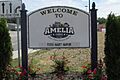
The Amelia welcome sign, removed in 2019.
-
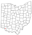
Location of Amelia, Ohio
-
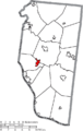
Location of Amelia in Clermont County
-
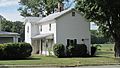
The Amelia Bowdoin House, a historic building in Amelia.
-
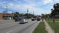
Main Street in Amelia, which is part of State Route 125.
See also
 In Spanish: Amelia (Ohio) para niños
