Parish of Amungula facts for kids
Quick facts for kids Amungula ParishNew South Wales |
|||||||||||||||
|---|---|---|---|---|---|---|---|---|---|---|---|---|---|---|---|

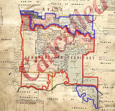
Early 20th Century cadastral map with highlights: The two sections of Amungula parish since 1909 Formerly part of the parish; transferred to the Commonwealth for the ACT in 1909
|
|||||||||||||||
| LGA(s) | Queanbeyan-Palerang Regional Council | ||||||||||||||
| County | Murray | ||||||||||||||
| Division | Eastern | ||||||||||||||
|
|||||||||||||||
Amungula Parish is a special way of dividing land in New South Wales, Australia. It's like an old-fashioned map section used to keep track of land ownership. This parish is part of Murray County, New South Wales.
What makes Amungula Parish interesting is that it's not all in one piece. It's split into two separate parts. This happened because a big chunk of the original parish became part of the Australian Capital Territory (ACT) in 1909.
Contents
What is a Parish?
A parish, in this sense, is a type of land division. It's not a church area, but a way to organize land for legal reasons. Think of it like a block on a very large map. These divisions help people know exactly where their land is and who owns it.
Parishes were created a long time ago. They are still used today for official land records and titles.
Where is Amungula Parish Located?
Amungula Parish is found in New South Wales. It's located near the city of Queanbeyan.
Because of the historical changes, the parish is now in two separate sections.
- The northern section is the larger part. It's located just south of a place called Wamboin. You can find it around these coordinates: 35°15′50″S 149°17′29″E / 35.26389°S 149.29139°E.
- The southern section is smaller. It's a piece of land between the Goulburn-Queanbeyan railway line and the Molonglo River. Its approximate location is 35°20′48″S 149°19′49″E / 35.34667°S 149.33028°E.
The Kings Highway is an important road that passes through a small part of the southern section of the parish.
A Split Parish: The ACT Connection
The main reason Amungula Parish is split is because of the creation of the Australian Capital Territory (ACT). In 1909, a large portion of the parish was transferred to the Commonwealth of Australia. This land became part of the ACT.
Today, much of that transferred land is part of the Kowen district within the ACT. This historical event divided the original parish into the two parts we see today.
Changes Over Time
Before 1909, the Molonglo River used to be the southern border of Amungula Parish. This shows how the boundaries of these land divisions can change over time.
Amungula Parish also changed which local government area it belonged to. It used to be part of the Yarrowlumla Shire. Now, it is managed by the Queanbeyan-Palerang Regional Council. This council is responsible for local services and planning in the area.
 | Bayard Rustin |
 | Jeannette Carter |
 | Jeremiah A. Brown |


