Amédée River facts for kids
Quick facts for kids Amédée River |
|
|---|---|

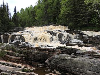
Chute de la rivière Amédée
|
|
| Country | Canada |
| Province | Quebec |
| Region | Côte-Nord |
| MRC | Manicouagan Regional County Municipality |
| City | Baie-Comeau |
| Physical characteristics | |
| Main source | Brassard Lake Baie-Comeau 81 m (266 ft) 49°15′02″N 68°18′31″W / 49.25056°N 68.30861°W |
| River mouth | Gulf of Saint Lawrence Baie-Comeau 2 m (6.6 ft) 49°11′11″N 68°14′21″W / 49.18639°N 68.23917°W |
| Length | 10.1 km (6.3 mi) |
| Basin features | |
| Tributaries |
|
The Amédée River is a small river in Quebec, Canada. It flows through the town of Baie-Comeau and eventually joins the mighty Saint Lawrence River. This river is important for the local area.
Forest roads help people access the eastern part of the Amédée river valley. The main road, Route 138, serves the lower part of the river.
Forestry, which is the business of managing and using forests, is the main economic activity in this river valley. The river usually freezes from early December to late March. However, it's generally safe to walk or play on the ice from mid-December to mid-March.
What's in a Name?
The Amédée River got its name from a person named Amédée Couillard-Després. He was the first manager of a sawmill built near the river's mouth. This sawmill was set up by Damase and Henri Jalbert in 1898.
The name "Amédée river" was officially recognized on December 5, 1968. This was done by the Place Names Bank of the Commission de toponymie du Québec.
Where Does the River Flow?
The Amédée River is part of the larger Manicouagan River system. It starts from Lake Amédée, which is about 2.6 kilometers (1.6 miles) long. This lake is located about 7.9 kilometers (4.9 miles) northwest of downtown Baie-Comeau.
Many smaller streams and outlets feed into Lake Amédée. These include water from Lake Hibou and Lake Marcel, as well as several other small lakes.
The Amédée River has a special dam that helps control the water flow. The river ends with some beautiful waterfalls near a place called Vieux Poste. After these falls, the river empties into the huge Saint Lawrence River.
The Amédée River flows for about 10.1 kilometers (6.3 miles). As it flows, the river drops about 79 meters (259 feet) in height.
River's Journey
- The river flows mostly southeast for about 5.9 kilometers (3.7 miles). It forms some bends along the way.
- Then, it continues southeast for about 2.7 kilometers (1.7 miles). Here, the river gets wider. It collects water from the Couillard stream and passes an industrial area. It also picks up water from Le Petit Bras before reaching the dam.
- Finally, the river flows for another 1.5 kilometers (0.9 miles) to its mouth. During this part, it crosses two areas with rapids. It also makes a loop towards the east before joining the Gulf of Saint Lawrence.
The Amédée River flows into a small bay on the north shore of the Gulf of Saint Lawrence. This spot is:
- About 6.2 kilometers (3.9 miles) northeast of the mouth of the Manicouagan River.
- About 3.8 kilometers (2.4 miles) northwest of Pointe-Lebel, where the local airport is located.
- About 3.7 kilometers (2.3 miles) southwest of the mouth of the rivière à la Chasse (Baie-Comeau).
 | Aaron Henry |
 | T. R. M. Howard |
 | Jesse Jackson |

