Anderson, Texas facts for kids
Quick facts for kids
Anderson
|
|
|---|---|

Anderson, Texas
|
|
| Country | United States |
| State | Texas |
| County | Grimes |
| Area | |
| • Total | 0.51 sq mi (1.33 km2) |
| • Land | 0.51 sq mi (1.33 km2) |
| • Water | 0.00 sq mi (0.00 km2) |
| Elevation | 335 ft (102 m) |
| Population
(2020)
|
|
| • Total | 193 |
| • Density | 472.66/sq mi (182.55/km2) |
| Time zone | UTC-6 (Central (CST)) |
| • Summer (DST) | UTC-5 (CDT) |
| ZIP codes |
77830, 77875
|
| Area code(s) | 936 |
| FIPS code | 48-03192 |
| GNIS feature ID | 2409707 |
| Website | http://andersontx.gov/ |
Anderson is a small city in Grimes County, Texas, United States. It is the main town, also known as the county seat. In 2020, about 193 people lived there. The town and its surrounding areas are special because they are listed on the National Register of Historic Places as the Anderson Historic District. This means they have important historical buildings and sites.
The town got its name from Kenneth Lewis Anderson. He was a vice-president of the Republic of Texas, which was an independent country before Texas joined the United States. He passed away in Anderson in 1845 at a place called the Fanthorp Inn.
Contents
History of Anderson
Early Settlements and Growth
Long ago, this area was home to indigenous peoples (native groups). Then, people from Europe and Spanish families started settling here during the time when Spain ruled Texas. In the 1820s, Anglo-Americans, mostly from the southern United States, began to arrive.
After Mexico became independent, it allowed more settlers from the United States to come to eastern Texas. They could practice their own religion if they promised loyalty to Mexico. Some buildings in Anderson today are from this early period.
Texas Independence and Slavery
Texas became independent in 1836, and more settlers kept coming from the United States. Many of these settlers came from the Southern states and brought enslaved people with them. Because of this, Grimes County and other eastern counties had a very high number of slaveholders and enslaved people.
Grimes County was officially set up in 1846, soon after Texas joined the United States. Henry Fanthorp, a new settler, gave land for the county seat. The town of Anderson grew quickly between 1846 and 1885. Its population reached about 3,000 people. By 1860, most of the county's population was Black and enslaved. This Black majority continued until many African Americans moved away in the 20th century during the Great Migration. They left to escape unfair laws and conditions.
Railroads and Town Revival
In 1859, Anderson decided not to connect to the Texas and Central Railroad. Because of this, a nearby town called Navasota grew much faster and became more important. Anderson couldn't catch up, even though it finally got a railroad in 1903. The town was officially recognized as a city, but records only show elected leaders for a few years in the 1800s.
In 1983, people tried to restart the city government, but it didn't happen. By 1995, Anderson had big problems with its sewer system. The state even threatened to close the county courthouse if the issues weren't fixed. One way to get money to fix the sewer system was for the town to become an official city again. So, in 1995, John Freeman was elected as the first mayor, and Anderson became an incorporated city in 1998. He retired in 2003, and Gail Sowell became the new mayor.
Geography and Climate
Where is Anderson?
Texas State Highway 90 goes through Anderson. If you go north about 7 miles, you'll reach Roans Prairie. If you go southwest about 9 miles, you'll get to Navasota, which is the biggest city in Grimes County. College Station is about 28 miles northwest, and Houston is about 71 miles southeast.
Anderson is a small town, covering an area of about 0.51 square miles (1.3 square kilometers). All of this area is land.
What is the Climate Like?
Anderson has a humid subtropical climate. This means it has hot and humid summers. The winters are usually mild to cool. On climate maps, this type of climate is often called "Cfa."
People of Anderson (Demographics)
| Historical population | |||
|---|---|---|---|
| Census | Pop. | %± | |
| 1990 | 370 | — | |
| 2000 | 257 | −30.5% | |
| 2010 | 222 | −13.6% | |
| 2020 | 193 | −13.1% | |
| U.S. Decennial Census 1990 data from TSHA Online | |||
| Race | Number | Percentage |
|---|---|---|
| White (NH) | 117 | 60.62% |
| Black or African American (52) | 52 | 26.94% |
| Some Other Race (NH) | 1 | 0.52% |
| Mixed/Multi-Racial (NH) | 3 | 1.55% |
| Hispanic or Latino | 20 | 10.36% |
| Total | 193 |
In 2020, there were 193 people living in Anderson. There were 85 households and 58 families.
Back in 2000, there were 257 people. About 21.7% of households had children under 18. Many households were married couples living together (46.7%). The average household had 2.35 people.
The median age in 2000 was 42 years old. This means half the people were younger than 42, and half were older.
Arts and Culture
Anderson Historic District
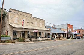
The entire town of Anderson and its nearby areas are part of the Anderson Historic District. This district was added to the National Register of Historic Places in 1974. It's special because many buildings from different periods of Texas history are still standing. These include buildings from when Mexico ruled Texas, when Texas was its own republic, and when it first became a U.S. state.
Anderson didn't grow as much economically after the late 1800s. Because of this, the town still looks a lot like it did at the beginning of the 20th century.
Some buildings in the district are also recognized as important Texas landmarks. Here are a few examples:
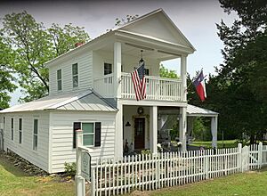
- Allen Home: Built around 1840, this building was first used as a school for girls.
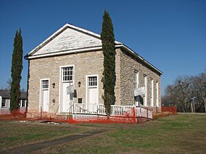
- Anderson Baptist Church: This church was built between 1853 and 1855. Enslaved African-American workers built it using local stone. The Baptist General Convention of Texas was formed here in 1848.
- Fanthorp Inn State Historic Site: This inn had the first post office in the area. In 1845, Kenneth Lewis Anderson, for whom the town is named, passed away while staying here. The Texas Parks and Wildlife Department bought the property in 1977. In 1987, it opened to the public. It shows what life was like at a stagecoach stop and family home in 1850.
- B. B. Goodrich House: Benjamin Briggs Goodrich was an important person who signed the Texas Declaration of Independence.
- The Harris-Martin House: This house belonged to a family important in founding Harrisburg, Texas (now part of Houston).
- Grimes County Courthouse: The main building for the county government.
Education
Students in Anderson attend public schools run by the Anderson-Shiro Consolidated Independent School District.
See also
 In Spanish: Anderson (Texas) para niños
 | Kyle Baker |
 | Joseph Yoakum |
 | Laura Wheeler Waring |
 | Henry Ossawa Tanner |


